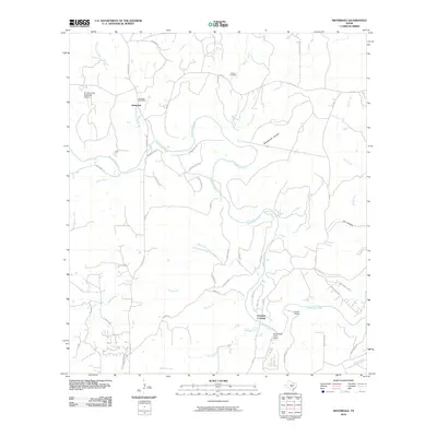
2010 Map of Sisterdale
USGS Topo · Published 2010About this map
The Guadalupe River winds through this Central Texas landscape, defining the character of the settlement at Sisterdale. As a historic gathering point in the Texas Hill Country, the area is anchored by the Sisterdale Post Office and the nearby Werner Cemetery, reflecting the lineage of local families. The map illustrates a network of rural routes like Sisterdale RD and FM 474 that connect sprawling ranch lands and aviation markers such as the B J McCombs Sisterdale Airport.
Find a feature on this map
47 named features on this map. Tap any name to fly to it.
Don’t see what you’re looking for? This feature index may not catch every label — zoom into the map to look around manually.
Map Details
Editions of this 2010 Sisterdale Map
This is the sole edition of this map. No revisions or reprints were ever made.
Other maps of this area

1894 · Fredericksburg
USGS Topo · 1:125,000

1954 · Llano
USGS Topo · 1:250,000

1954 · San Antonio
USGS Topo · 1:250,000

1955 · Llano
USGS Topo · 1:250,000

1956 · Comfort
USGS Topo · 1:62,500

1956 · Llano
USGS Topo · 1:250,000

1957 · Boerne
USGS Topo · 1:62,500

1957 · San Antonio
USGS Topo · 1:250,000
1963 · Crabapple Creek
USGS Topo · 1:24,000

1963 · Whitworth Ranch
USGS Topo · 1:24,000