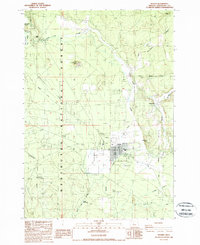
1988 Map of Sisters
USGS Topo · Published 1988About this map
Sisters serves as the focal point of this late-1980s landscape, situated where the high desert meets the eastern foothills of the Cascades. The map reveals a transition from the structured street grid of the town to the surrounding Deschutes National Forest, marked by clear corporate and forest boundaries. Historical transportation routes are prominent, with the Santiam Wagon Road and Metolius-Windigo Trail cutting through the western sections, indicating the region's legacy of frontier travel and modern recreation. Water management is a defining characteristic of the terrain, visible through the network of the Squaw Creek and Indian Ford Creek drainages alongside a man-made Sisters Reservoir and various irrigation ditches. Landmarks like the Historical Monument and Sisters Cow Camp point to the local heritage of ranching and early settlement near Camp Polk.
Find a feature on this map
34 named features on this map. Tap any name to fly to it.
Don’t see what you’re looking for? This feature index may not catch every label — zoom into the map to look around manually.
Map Details
Editions of this 1988 Sisters Map
This is the sole edition of this map. No revisions or reprints were ever made.
Other maps of this area

1926 · Bend
USGS Topo · 1:125,000

1929 · Bend
USGS Topo · 1:125,000

1929 · Three Sisters
USGS Topo · 1:125,000

1932 · Three Sisters
USGS Topo · 1:125,000

1955 · Bend
USGS Topo · 1:250,000

1957 · Bend
USGS Topo · 1:250,000

1958 · Bend
USGS Topo · 1:250,000

1959 · Broken Top
USGS Topo · 1:62,500

1959 · Sisters
USGS Topo · 1:62,500
1962 · Squaw Back Ridge
USGS Topo · 1:24,000