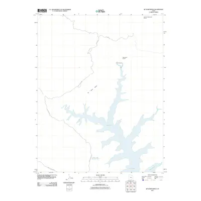
2011 Map of Sit Down Bench
USGS Topo · Published 2011About this map
Lake Powell dominates the southeastern portion of this map, its intricate fingers and coves reaching into the desert floor of southern Utah. The high plateau of Sit Down Bench stands above the water, accessed by the winding course of Smokey Mountain Rd. This high-desert terrain is marked by deep incisions from drainage systems such as Croton Canyon and Little Valley Canyon, which flow toward the reservoir. On the western edge, Last Chance Creek cuts through the arid landscape. Evidence of desert water management is found at the Point of the Mountain Tank, while the northern reaches include the headwaters of Left Fork Chynoweth Canyon, highlighting the complex topography of the Glen Canyon region during the early twenty-first century.
Find a feature on this map
10 named features on this map. Tap any name to fly to it.
Don’t see what you’re looking for? This feature index may not catch every label — zoom into the map to look around manually.
Map Details
Editions of this 2011 Sit Down Bench Map
This is the sole edition of this map. No revisions or reprints were ever made.
Other maps of this area

1886 · Escalante
USGS Topo · 1:250,000

1922 · Warm Creek
USGS Topo · 1:63,360

1922 · Rees Canyon
USGS Topo · 1:63,360

1953 · Cummings Mesa
USGS Topo · 1:62,500

1953 · Gunsight Butte
USGS Topo · 1:62,500

1956 · Escalante
USGS Topo · 1:250,000

1960 · Escalante
USGS Topo · 1:250,000

1968 · East of The Navajo
USGS Topo · 1:24,000
1968 · Needle Eye Point
USGS Topo · 1:24,000
1968 · Blackburn Canyon
USGS Topo · 1:24,000