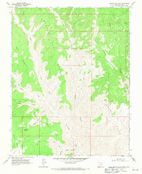
1968 Map of Needle Eye Point
USGS Topo · Published 1971About this map
Needle Eye Point stands as a prominent landmark in this desert landscape of southern Kane County, surveyed in the late 1960s. The terrain is defined by complex drainage systems and high plateaus, including Dry Bench and the enigmatic Wind O Sash. Water is a scarce but critical resource here, marked by Needle Eye Water and the confluence of the Right Fork and Left Fork at Water Canyon. The presence of a lone Oil Well near Navajo Canyon indicates mid-century resource exploration in an otherwise desolate reach. Transportation is limited to a sparse network of rugged paths, such as the Jeep Tr and various unnamed trails that navigate the slopes of Smoky Mountain and the Burning Hills, reflecting the area's isolation during this era of geologic study.
Find a feature on this map
23 named features on this map. Tap any name to fly to it.
Don’t see what you’re looking for? This feature index may not catch every label — zoom into the map to look around manually.
Map Details
Editions of this 1968 Needle Eye Point Map
2 editions found
Other maps of this area

1886 · Escalante
USGS Topo · 1:250,000

1922 · Warm Creek
USGS Topo · 1:63,360

1922 · Upper Last Chance
USGS Topo · 1:63,360

1922 · Rees Canyon
USGS Topo · 1:63,360

1953 · Nipple Butte
USGS Topo · 1:62,500

1953 · Gunsight Butte
USGS Topo · 1:62,500

1956 · Escalante
USGS Topo · 1:250,000

1960 · Escalante
USGS Topo · 1:250,000

1968 · East of The Navajo
USGS Topo · 1:24,000
1968 · Petes Cove
USGS Topo · 1:24,000