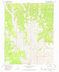
1968 Map of Needle Eye Point
USGS Topo · Published 1980About this map
Needle Eye Point anchors this high-desert landscape in Kane County, defined by a network of deep drainages and steep escarpments surveyed in the late 1960s. The terrain transitions from the Burning Hills in the east toward the high ridge of Smoky Mountain in the southwest, separated by the extensive plateau of Wind O Sash. The scarcity of water in this arid environment is highlighted by the named Needle Eye Water spring and seasonal drainage systems like Dry Wash and Last Chance Creek. Transportation is limited to a sparse network of jeep trails that navigate around landmarks such as Shute Point and through Whities Canyon. A lone Oil Well in the northeast corner of the quadrangle suggests the era's focus on resource exploration within these remote canyonlands.
Find a feature on this map
24 named features on this map. Tap any name to fly to it.
Don’t see what you’re looking for? This feature index may not catch every label — zoom into the map to look around manually.
Map Details
Editions of this 1968 Needle Eye Point Map
2 editions found
Other maps of this area

1886 · Escalante
USGS Topo · 1:250,000

1922 · Warm Creek
USGS Topo · 1:63,360

1922 · Upper Last Chance
USGS Topo · 1:63,360

1922 · Rees Canyon
USGS Topo · 1:63,360

1953 · Nipple Butte
USGS Topo · 1:62,500

1953 · Gunsight Butte
USGS Topo · 1:62,500

1956 · Escalante
USGS Topo · 1:250,000

1960 · Escalante
USGS Topo · 1:250,000

1968 · East of The Navajo
USGS Topo · 1:24,000
1968 · Petes Cove
USGS Topo · 1:24,000