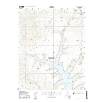
2017 Map of Sit Down Bench
USGS Topo · Published 2017About this map
Lake Powell dominates the southern half of this landscape, its fingers reaching into deep incisions like Last Chance Bay and Croton Canyon. This terrain, situated within the Glen Canyon National Recreation Area, is defined by expansive elevated plateaus including Sit Down Bench and Grand Bench. To the west, the Burning Hills and Smoky Mtn rise above the drainage of Last Chance Cr. The map captures a high-desert wilderness marked by isolated water sources like Point of the Mountain Tank and geological landmarks such as White Rocks. While largely roadless, the area is traversable via the Sit Down Bench Trail and Little Valley Road, reflecting the intersection of protected federal land and traditional backcountry access routes near the Arizona border.
Find a feature on this map
25 named features on this map. Tap any name to fly to it.
Don’t see what you’re looking for? This feature index may not catch every label — zoom into the map to look around manually.
Map Details
Editions of this 2017 Sit Down Bench Map
This is the sole edition of this map. No revisions or reprints were ever made.
Other maps of this area

1886 · Escalante
USGS Topo · 1:250,000

1922 · Warm Creek
USGS Topo · 1:63,360

1922 · Rees Canyon
USGS Topo · 1:63,360

1953 · Cummings Mesa
USGS Topo · 1:62,500

1953 · Gunsight Butte
USGS Topo · 1:62,500

1956 · Escalante
USGS Topo · 1:250,000

1960 · Escalante
USGS Topo · 1:250,000

1968 · East of The Navajo
USGS Topo · 1:24,000
1968 · Needle Eye Point
USGS Topo · 1:24,000
1968 · Blackburn Canyon
USGS Topo · 1:24,000