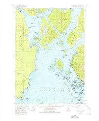
1951 Map of Sitka A-5
USGS Topo · Published 1976About this map
Sitka and its intricate island-studded approaches define this mid-century coastal survey. The geography is dominated by the waterways of the Alexander Archipelago, including Krestof Sound, Olga Strait, and the Nakwasina Passage, which separate large landmasses like Kruzof Island and Baranof Island. The map records layers of human history, from the Old Sitka (Ruins) at Starrigavan Bay to the more modern Army Camp (Abandoned) on the western shore. The presence of a Pipeline and the sprawling Tongass National Forest boundary highlight the mid-century industrial and conservation footprint on the Alaskan panhandle. Navigational landmarks like Japonski Island and Whiting Harbor provide essential context for the maritime development of the state's former capital, showing the transition from isolated outpost to a connected regional hub.
Find a feature on this map
47 named features on this map. Tap any name to fly to it.
Don’t see what you’re looking for? This feature index may not catch every label — zoom into the map to look around manually.
Map Details
Editions of this 1951 Sitka A-5 Map

Other maps of this area

1948 · Sitka A-5
USGS Topo · 1:63,360

1948 · Sitka B-5
USGS Topo · 1:63,360

1951 · Sitka B-4
USGS Topo · 1:63,360

1951 · Sitka A-6
USGS Topo · 1:63,360

1951 · Sitka B-6
USGS Topo · 1:63,360

1951 · Sitka B-5
USGS Topo · 1:63,360

1951 · Port Alexander D-5
USGS Topo · 1:63,360

1951 · Sitka
USGS Topo · 1:250,000

1951 · Port Alexander D-4
USGS Topo · 1:63,360

1951 · Port Alexander
USGS Topo · 1:250,000