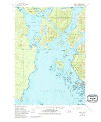
1951 Map of Sitka A-5
USGS Topo · Published 1995About this map
Sitka serves as the focal point of this coastal survey, situated on the western edge of Baranof Island where the Eastern Channel meets the intricate waterways of Sitka Sound. The map documents the area during the early 1950s, a period of transition following World War II, evidenced by the Army Camp (Abandoned) on the southern coast of Kruzof Island near Mt Edgecumbe. The maritime character of the region is defined by complex passages like Neva Strait and Nakwasina Passage, which separate a dense archipelago including Halleck Island, Krestof Island, and Japonski Island. Local history is visible in the ruins at Old Sitka (Runs) on the shores of Starrigavan Bay, while smaller settlements like Brady appear as isolated outposts. The landscape's industrial and infrastructure layers include a Pipeline near the main townsite and an Observation Tower overlooking the Pacific approaches, all contained within the boundaries of the Tongass National Forest.
Find a feature on this map
61 named features on this map. Tap any name to fly to it.
Don’t see what you’re looking for? This feature index may not catch every label — zoom into the map to look around manually.
Map Details
Editions of this 1951 Sitka A-5 Map

Other maps of this area

1948 · Sitka A-5
USGS Topo · 1:63,360

1948 · Sitka B-5
USGS Topo · 1:63,360

1951 · Sitka B-4
USGS Topo · 1:63,360

1951 · Sitka A-6
USGS Topo · 1:63,360

1951 · Sitka B-6
USGS Topo · 1:63,360

1951 · Sitka B-5
USGS Topo · 1:63,360

1951 · Port Alexander D-5
USGS Topo · 1:63,360

1951 · Sitka
USGS Topo · 1:250,000

1951 · Port Alexander D-4
USGS Topo · 1:63,360

1951 · Port Alexander
USGS Topo · 1:250,000