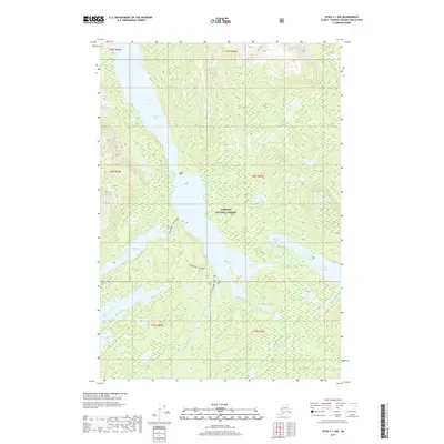
2017 Map of Sitka C-1 NW
USGS Topo · Published 2017About this map
Tongass National Forest dominates this Admiralty Island landscape, characterized by an intricate network of freshwater lakes and drainage systems. The prominent Hasselborg Lake serves as a central hub for the region's hydrography, connected to surrounding waters via Hasselborg Creek. The map documents two specific portage or overland routes, Hasselborg to McKinney and Hasselborg to Guerin, which illustrate the historical and practical movement between these isolated water bodies. These paths provide a tangible link between McKinney Lake, Lake Guerin, and the larger Hasselborg system. Smaller basins like Sikady Lake, Beaver Lake, and Lake Alexander are scattered throughout the interior, while the Molo River and Bear Cr drain the higher elevations. The absence of modern infrastructure highlights the preserved wilderness state of this portion of the Unorganized Borough in the early 21st century.
Find a feature on this map
22 named features on this map. Tap any name to fly to it.
Don’t see what you’re looking for? This feature index may not catch every label — zoom into the map to look around manually.
Map Details
Editions of this 2017 Sitka C-1 NW Map
This is the sole edition of this map. No revisions or reprints were ever made.
Other maps of this area

1948 · Sitka D-1
USGS Topo · 1:63,360

1948 · Sitka C-2
USGS Topo · 1:63,360

1948 · Sitka D-2
USGS Topo · 1:63,360

1948 · Sitka C-1
USGS Topo · 1:63,360

1951 · Sitka
USGS Topo · 1:250,000

1951 · Sitka D-1
USGS Topo · 1:63,360

1951 · Sitka C-1
USGS Topo · 1:63,360

1951 · Sitka D-2
USGS Topo · 1:63,360

1951 · Sitka C-2
USGS Topo · 1:63,360

1952 · Sitka
USGS Topo · 1:250,000