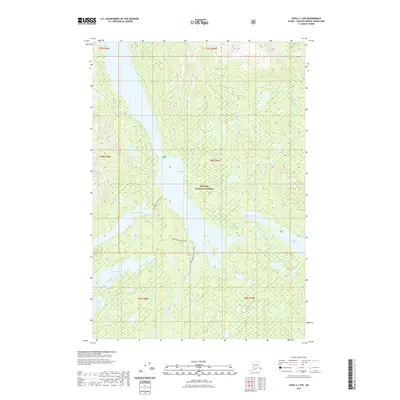
2021 Map of Sitka C-1 NW
USGS Topo · Published 2021About this map
Tongass National Forest defines the environment of this Southeast Alaska wilderness, where a complex network of freshwater bodies is connected by established portage and river routes. Central to this landscape is Hasselborg Lake, which serves as a navigational hub for the Hasselborg to McKinney Trl and the Hasselborg to Guerin Trl. These trails, along with the Hasselborg River Trl, trace the historic movement patterns through the dense forest and marshlands between Lake Alexander and Davidson Lake. The drainage system is further detailed by the presence of the Mole River and Hasselborg Creek, illustrating the intricate hydrological connections of the Admiralty Island area. Other notable interior waters include Coo Lake, Beaver Lake, and Islet Lake, reflecting the saturated, high-latitude terrain of the Alexander Archipelago.
Find a feature on this map
22 named features on this map. Tap any name to fly to it.
Don’t see what you’re looking for? This feature index may not catch every label — zoom into the map to look around manually.
Map Details
Editions of this 2021 Sitka C-1 NW Map
This is the sole edition of this map. No revisions or reprints were ever made.
Other maps of this area

1948 · Sitka D-1
USGS Topo · 1:63,360

1948 · Sitka C-2
USGS Topo · 1:63,360

1948 · Sitka D-2
USGS Topo · 1:63,360

1948 · Sitka C-1
USGS Topo · 1:63,360

1951 · Sitka
USGS Topo · 1:250,000

1951 · Sitka D-1
USGS Topo · 1:63,360

1951 · Sitka C-1
USGS Topo · 1:63,360

1951 · Sitka D-2
USGS Topo · 1:63,360

1951 · Sitka C-2
USGS Topo · 1:63,360

1952 · Sitka
USGS Topo · 1:250,000