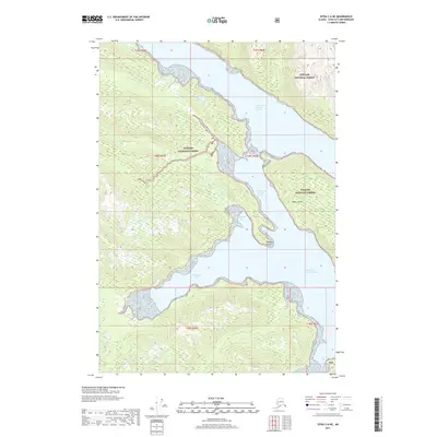
2017 Map of Sitka C-6 NE
USGS Topo · Published 2017About this map
The complex shoreline of Tongass National Forest dominates this coastal survey, where the deep glacial waters of Chichagof Island meet the Alexander Archipelago. The intricate network of fjords is defined by the North Arm and South Arm of Hoonah Sound, which segment the land into a series of steep-sided peninsulas. At the heart of these waters lies Moser Island, a significant landmass flanked by deep-water passages. Several protected inlets, including Douglass Bay, Patterson Bay, and Fick Cove, indent the coastline, indicating a landscape where maritime access is the primary mode of navigation. Apart from the natural geographic features like Reynard Point, the map reflects a purely wilderness environment managed by the U.S. Forest Service, devoid of permanent settlements or road infrastructure during this period.
Find a feature on this map
14 named features on this map. Tap any name to fly to it.
Don’t see what you’re looking for? This feature index may not catch every label — zoom into the map to look around manually.
Map Details
Editions of this 2017 Sitka C-6 NE Map
This is the sole edition of this map. No revisions or reprints were ever made.
Other maps of this area

1948 · Sitka D-5
USGS Topo · 1:63,360

1948 · Sitka C-6
USGS Topo · 1:63,360

1948 · Sitka D-6
USGS Topo · 1:63,360

1951 · Sitka C-5
USGS Topo · 1:63,360

1951 · Sitka
USGS Topo · 1:250,000

1951 · Sitka C-6
USGS Topo · 1:63,360

1951 · Sitka D-6
USGS Topo · 1:63,360

1951 · Sitka D-5
USGS Topo · 1:63,360

1952 · Sitka
USGS Topo · 1:250,000

1964 · Sitka
USGS Topo · 1:250,000