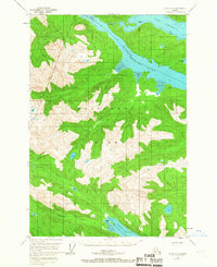
1951 Map of Sitka D-6
USGS Topo · Published 1967About this map
Chichagof Island dominates this mid-century topographic survey, showing a landscape defined by deep fjords and maritime pathways. The interior of the island is marked by the course of the Lisianski River and the high elevations within the Tongass National Forest. The map emphasizes the critical land-to-water connections of the era, notably at Portage, a strategic point where land routes bridged the narrow gap between the waters of Port Frederick and the long reach of Tenakee Inlet.
Find a feature on this map
12 named features on this map. Tap any name to fly to it.
Don’t see what you’re looking for? This feature index may not catch every label — zoom into the map to look around manually.
Map Details
Editions of this 1951 Sitka D-6 Map
3 editions found
Historical Maps of Unorganized Borough Through Time
247 maps found

1948 Port Alexander A-2
Sitka Borough, AK

1948 Port Alexander A-3
Sitka Borough, AK

1948 Port Alexander B-2
Sitka Borough, AK

1948 Sitka A-3
Sitka Borough, AK

1948 Sitka A-5
Sitka Borough, AK

1948 Sitka B-3
Sitka Borough, AK

1948 Sitka B-5
Sitka Borough, AK

1948 Sitka C-3
Sitka Borough, AK

1948 Sitka C-6
Sitka Borough, AK

1948 Sitka C-7
Sitka Borough, AK

1948 Sitka D-6
Sitka Borough, AK

1951 Port Alexander A-2
Sitka Borough, AK

1951 Port Alexander A-3
Sitka Borough, AK

1951 Port Alexander B-2
Sitka Borough, AK

1951 Port Alexander B-3 and B-4
Sitka Borough, AK

1951 Port Alexander C-2
Sitka Borough, AK

1951 Port Alexander C-3
Sitka Borough, AK

1951 Port Alexander C-4
Sitka Borough, AK

1951 Port Alexander D-3
Sitka Borough, AK

1951 Port Alexander D-4
Sitka Borough, AK

1951 Port Alexander D-5
Sitka Borough, AK

1951 Port Alexander
Sitka Borough, AK

1951 Sitka A-3
Sitka Borough, AK

1951 Sitka A-4
Sitka Borough, AK

1951 Sitka A-5
Sitka Borough, AK

1951 Sitka A-6
Sitka Borough, AK

1951 Sitka B-3
Sitka Borough, AK

1951 Sitka B-4
Sitka Borough, AK

1951 Sitka B-5
Sitka Borough, AK

1951 Sitka B-6
Sitka Borough, AK

1951 Sitka C-3
Sitka Borough, AK

1951 Sitka C-4
Sitka Borough, AK

1951 Sitka C-5
Sitka Borough, AK

1951 Sitka C-6
Sitka Borough, AK

1951 Sitka C-7
Sitka Borough, AK

1951 Sitka D-6
Sitka Borough, AK

1952 Port Alexander
Sitka Borough, AK

1954 Sitka A-4
Sitka Borough, AK

1964 Port Alexander
Sitka Borough, AK

1987 Sitka A-4 SW
Sitka Borough, AK

1987 Sitka A-5 SE
Sitka Borough, AK

1994 Port Alexander C-3
Sitka Borough, AK

1994 Port Alexander C-4
Sitka Borough, AK

1994 Sitka C-7
Sitka Borough, AK

1995 Port Alexander D-3
Sitka Borough, AK

1996 Sitka A-3
Sitka Borough, AK

1996 Sitka A-5
Sitka Borough, AK

1996 Sitka B-5
Sitka Borough, AK

1996 Sitka B-6
Sitka Borough, AK

1997 Sitka B-3
Sitka Borough, AK

1997 Sitka C-3
Sitka Borough, AK

2000 Sitka D-6
Sitka Borough, AK

2017 Port Alexander A-2 NW
Sitka Borough, AK

2017 Port Alexander A-3 NE
Sitka Borough, AK

2017 Port Alexander B-2 NW
Sitka Borough, AK

2017 Port Alexander B-2 SW
Sitka Borough, AK

2017 Port Alexander B-3 NE
Sitka Borough, AK

2017 Port Alexander B-3 NW
Sitka Borough, AK

2017 Port Alexander B-3 SE
Sitka Borough, AK

2017 Port Alexander B-3 SW
Sitka Borough, AK

2017 Port Alexander B-4 NE
Sitka Borough, AK

2017 Port Alexander C-2 NE
Sitka Borough, AK

2017 Port Alexander C-2 NW
Sitka Borough, AK

2017 Port Alexander C-2 SW
Sitka Borough, AK

2017 Port Alexander C-3 NE
Sitka Borough, AK

2017 Port Alexander C-3 NW
Sitka Borough, AK

2017 Port Alexander C-3 SE
Sitka Borough, AK

2017 Port Alexander C-3 SW
Sitka Borough, AK

2017 Port Alexander C-4 NE
Sitka Borough, AK

2017 Port Alexander C-4 NW
Sitka Borough, AK

2017 Port Alexander C-4 SE
Sitka Borough, AK

2017 Port Alexander D-2 SW
Sitka Borough, AK

2017 Port Alexander D-3 NE
Sitka Borough, AK

2017 Port Alexander D-3 NW
Sitka Borough, AK

2017 Port Alexander D-3 SE
Sitka Borough, AK

2017 Port Alexander D-3 SW
Sitka Borough, AK

2017 Port Alexander D-4 NE
Sitka Borough, AK

2017 Port Alexander D-4 NW
Sitka Borough, AK

2017 Port Alexander D-4 SE
Sitka Borough, AK

2017 Port Alexander D-4 SW
Sitka Borough, AK

2017 Port Alexander D-5 NE
Sitka Borough, AK

2017 Port Alexander D-5 NW
Sitka Borough, AK

2017 Port Alexander D-5 SE
Sitka Borough, AK

2017 Port Alexander D-5 SW
Sitka Borough, AK

2017 Sitka A-3 NE
Sitka Borough, AK

2017 Sitka A-3 NW
Sitka Borough, AK

2017 Sitka A-3 SE
Sitka Borough, AK

2017 Sitka A-3 SW
Sitka Borough, AK

2017 Sitka A-4 NE
Sitka Borough, AK

2017 Sitka A-4 NW
Sitka Borough, AK

2017 Sitka A-4 SE
Sitka Borough, AK

2017 Sitka A-4 SW
Sitka Borough, AK

2017 Sitka A-5 NE
Sitka Borough, AK

2017 Sitka A-5 NW
Sitka Borough, AK

2017 Sitka A-5 SE
Sitka Borough, AK

2017 Sitka A-5 SW
Sitka Borough, AK

2017 Sitka A-6 NE
Sitka Borough, AK

2017 Sitka A-6 NW
Sitka Borough, AK

2017 Sitka A-6 OE S NE
Sitka Borough, AK

2017 Sitka A-6 OE S NW
Sitka Borough, AK

2017 Sitka A-6 SE
Sitka Borough, AK

2017 Sitka A-6 SW
Sitka Borough, AK

2017 Sitka B-3 NE
Sitka Borough, AK

2017 Sitka B-3 NW
Sitka Borough, AK

2017 Sitka B-3 SE
Sitka Borough, AK

2017 Sitka B-3 SW
Sitka Borough, AK

2017 Sitka B-4 NE
Sitka Borough, AK

2017 Sitka B-4 NW
Sitka Borough, AK

2017 Sitka B-4 SE
Sitka Borough, AK

2017 Sitka B-4 SW
Sitka Borough, AK

2017 Sitka B-5 NE
Sitka Borough, AK

2017 Sitka B-5 NW
Sitka Borough, AK

2017 Sitka B-5 SE
Sitka Borough, AK

2017 Sitka B-5 SW
Sitka Borough, AK

2017 Sitka B-6 NE
Sitka Borough, AK

2017 Sitka B-6 NW
Sitka Borough, AK

2017 Sitka B-6 SE
Sitka Borough, AK

2017 Sitka B-6 SW
Sitka Borough, AK

2017 Sitka C-3 NE
Sitka Borough, AK

2017 Sitka C-3 NW
Sitka Borough, AK

2017 Sitka C-3 SE
Sitka Borough, AK

2017 Sitka C-3 SW
Sitka Borough, AK

2017 Sitka C-4 NE
Sitka Borough, AK

2017 Sitka C-4 NW
Sitka Borough, AK

2017 Sitka C-4 SE
Sitka Borough, AK

2017 Sitka C-4 SW
Sitka Borough, AK

2017 Sitka C-5 NE
Sitka Borough, AK

2017 Sitka C-5 NW
Sitka Borough, AK

2017 Sitka C-5 SE
Sitka Borough, AK

2017 Sitka C-5 SW
Sitka Borough, AK

2017 Sitka C-6 NE
Sitka Borough, AK

2017 Sitka C-6 NW
Sitka Borough, AK

2017 Sitka C-6 SE
Sitka Borough, AK

2017 Sitka C-6 SW
Sitka Borough, AK

2017 Sitka C-7 NE
Sitka Borough, AK

2017 Sitka C-7 NW
Sitka Borough, AK

2017 Sitka C-7 OE S NE
Sitka Borough, AK

2017 Sitka C-7 SE
Sitka Borough, AK

2017 Sitka D-5 SE
Sitka Borough, AK

2017 Sitka D-5 SW
Sitka Borough, AK

2017 Sitka D-6 NE
Sitka Borough, AK

2017 Sitka D-6 NW
Sitka Borough, AK

2017 Sitka D-6 SE
Sitka Borough, AK

2017 Sitka D-6 SW
Sitka Borough, AK

2017 Sitka D-7 SE
Sitka Borough, AK

2017 Sitka D-7 SW
Sitka Borough, AK

2017 Sitka D-8 SE
Sitka Borough, AK

2018 Port Alexander C-4 OE W NE
Sitka Borough, AK

2018 Port Alexander C-4 SW
Sitka Borough, AK

2021 Port Alexander A-2 NW
Sitka Borough, AK

2021 Port Alexander A-3 NE
Sitka Borough, AK

2021 Port Alexander B-2 NW
Sitka Borough, AK

2021 Port Alexander B-2 SW
Sitka Borough, AK

2021 Port Alexander B-3 NE
Sitka Borough, AK

2021 Port Alexander B-3 NW
Sitka Borough, AK

2021 Port Alexander B-3 SE
Sitka Borough, AK

2021 Port Alexander B-3 SW
Sitka Borough, AK

2021 Port Alexander B-4 NE
Sitka Borough, AK

2021 Port Alexander C-2 NE
Sitka Borough, AK

2021 Port Alexander C-2 NW
Sitka Borough, AK

2021 Port Alexander C-2 SW
Sitka Borough, AK

2021 Port Alexander C-3 NE
Sitka Borough, AK

2021 Port Alexander C-3 NW
Sitka Borough, AK

2021 Port Alexander C-3 SE
Sitka Borough, AK

2021 Port Alexander C-3 SW
Sitka Borough, AK

2021 Port Alexander C-4 NE
Sitka Borough, AK

2021 Port Alexander C-4 NW
Sitka Borough, AK

2021 Port Alexander C-4 OE W NE
Sitka Borough, AK

2021 Port Alexander C-4 SE
Sitka Borough, AK

2021 Port Alexander D-2 SW
Sitka Borough, AK

2021 Port Alexander D-3 NE
Sitka Borough, AK

2021 Port Alexander D-3 NW
Sitka Borough, AK

2021 Port Alexander D-3 SE
Sitka Borough, AK

2021 Port Alexander D-3 SW
Sitka Borough, AK

2021 Port Alexander D-4 NE
Sitka Borough, AK

2021 Port Alexander D-4 NW
Sitka Borough, AK

2021 Port Alexander D-4 SE
Sitka Borough, AK

2021 Port Alexander D-4 SW
Sitka Borough, AK

2021 Port Alexander D-5 NE
Sitka Borough, AK

2021 Port Alexander D-5 NW
Sitka Borough, AK

2021 Port Alexander D-5 SE
Sitka Borough, AK

2021 Port Alexander D-5 SW
Sitka Borough, AK

2021 Sitka A-3 NE
Sitka Borough, AK

2021 Sitka A-3 NW
Sitka Borough, AK

2021 Sitka A-3 SE
Sitka Borough, AK

2021 Sitka A-3 SW
Sitka Borough, AK

2021 Sitka A-4 NE
Sitka Borough, AK

2021 Sitka A-4 NW
Sitka Borough, AK

2021 Sitka A-4 SE
Sitka Borough, AK

2021 Sitka A-4 SW
Sitka Borough, AK

2021 Sitka A-5 NE
Sitka Borough, AK

2021 Sitka A-5 NW
Sitka Borough, AK

2021 Sitka A-5 SE
Sitka Borough, AK

2021 Sitka A-5 SW
Sitka Borough, AK

2021 Sitka A-6 NE
Sitka Borough, AK

2021 Sitka A-6 NW
Sitka Borough, AK

2021 Sitka A-6 OE S NE
Sitka Borough, AK

2021 Sitka A-6 OE S NW
Sitka Borough, AK

2021 Sitka A-6 SE
Sitka Borough, AK

2021 Sitka A-6 SW
Sitka Borough, AK

2021 Sitka B-3 NE
Sitka Borough, AK

2021 Sitka B-3 NW
Sitka Borough, AK

2021 Sitka B-3 SE
Sitka Borough, AK

2021 Sitka B-3 SW
Sitka Borough, AK

2021 Sitka B-4 NE
Sitka Borough, AK

2021 Sitka B-4 NW
Sitka Borough, AK

2021 Sitka B-4 SE
Sitka Borough, AK

2021 Sitka B-4 SW
Sitka Borough, AK

2021 Sitka B-5 NE
Sitka Borough, AK

2021 Sitka B-5 NW
Sitka Borough, AK

2021 Sitka B-5 SE
Sitka Borough, AK

2021 Sitka B-5 SW
Sitka Borough, AK

2021 Sitka B-6 NE
Sitka Borough, AK

2021 Sitka B-6 NW
Sitka Borough, AK

2021 Sitka B-6 SE
Sitka Borough, AK

2021 Sitka B-6 SW
Sitka Borough, AK

2021 Sitka C-3 NE
Sitka Borough, AK

2021 Sitka C-3 NW
Sitka Borough, AK

2021 Sitka C-3 SE
Sitka Borough, AK

2021 Sitka C-3 SW
Sitka Borough, AK

2021 Sitka C-4 NE
Sitka Borough, AK

2021 Sitka C-4 NW
Sitka Borough, AK

2021 Sitka C-4 SE
Sitka Borough, AK

2021 Sitka C-4 SW
Sitka Borough, AK

2021 Sitka C-5 NE
Sitka Borough, AK

2021 Sitka C-5 NW
Sitka Borough, AK

2021 Sitka C-5 SE
Sitka Borough, AK

2021 Sitka C-5 SW
Sitka Borough, AK

2021 Sitka C-6 NE
Sitka Borough, AK

2021 Sitka C-6 NW
Sitka Borough, AK

2021 Sitka C-6 SE
Sitka Borough, AK

2021 Sitka C-6 SW
Sitka Borough, AK

2021 Sitka C-7 NE
Sitka Borough, AK

2021 Sitka C-7 NW
Sitka Borough, AK

2021 Sitka C-7 OE S NE
Sitka Borough, AK

2021 Sitka C-7 SE
Sitka Borough, AK

2021 Sitka D-5 SE
Sitka Borough, AK

2021 Sitka D-5 SW
Sitka Borough, AK

2021 Sitka D-6 NE
Sitka Borough, AK

2021 Sitka D-6 NW
Sitka Borough, AK

2021 Sitka D-6 SE
Sitka Borough, AK

2021 Sitka D-6 SW
Sitka Borough, AK

2021 Sitka D-7 SE
Sitka Borough, AK

2021 Sitka D-7 SW
Sitka Borough, AK

2021 Sitka D-8 SE
Sitka Borough, AK

2024 Sitka C-3 NE
Sitka Borough, AK

2024 Sitka C-3 SE
Sitka Borough, AK