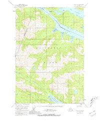
1951 Map of Sitka D-6
USGS Topo · Published 1981About this map
Chichagof Island dominates this 1951 topographic study, revealing a complex network of glacial fjords and drainage systems within the Tongass National Forest. The land is defined by deep incisions like Tenakee Inlet to the north and the North Arm Hoonah Sound to the south, showcasing the maritime-dependent geography of the City and Borough of Sitka. A notable terrestrial passage exists at Portage, where a narrow neck of land separates the waters of Port Frederick from the inland reach of the Tenakee.
Find a feature on this map
11 named features on this map. Tap any name to fly to it.
Don’t see what you’re looking for? This feature index may not catch every label — zoom into the map to look around manually.
Map Details
Editions of this 1951 Sitka D-6 Map
3 editions found

Other maps of this area

1948 · Sitka C-7
USGS Topo · 1:63,360

1948 · Sitka D-5
USGS Topo · 1:63,360

1948 · Sitka C-6
USGS Topo · 1:63,360

1948 · Sitka D-6
USGS Topo · 1:63,360

1948 · Mount Fairweather A-1
USGS Topo · 1:63,360

1951 · Juneau
USGS Topo · 1:250,000

1951 · Juneau A-6
USGS Topo · 1:63,360

1951 · Juneau A-5
USGS Topo · 1:63,360

1951 · Sitka D-7
USGS Topo · 1:63,360

1951 · Mt Fairweather
USGS Topo · 1:250,000