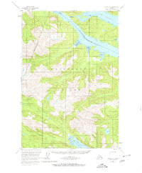
1951 Map of Sitka D-6
USGS Topo · Published 1980About this map
Chichagof Island dominates this 1951 topographic study, which captures the intricate coastline of the Alexander Archipelago before the onset of modern industrial shifts. The landscape is defined by its dramatic glacial carved waterways, notably Tenakee Inlet and Port Frederick in the north, and the North Arm Hoonah Sound along the southern margin. The map provides a detailed view of the intertidal zones, specifically the extensive Tidal Flats found at the heads of these inlets and bays. Inland, the drainage systems of the Lisianski River and Granite Creek reveal the complex hydrology of the island's interior. A notable portage point, labeled simply as Portage, indicates the historic routes used to navigate between the major water bodies where the land narrows near Bell I.
Find a feature on this map
11 named features on this map. Tap any name to fly to it.
Don’t see what you’re looking for? This feature index may not catch every label — zoom into the map to look around manually.
Map Details
Editions of this 1951 Sitka D-6 Map
3 editions found

Other maps of this area

1948 · Sitka C-7
USGS Topo · 1:63,360

1948 · Sitka D-5
USGS Topo · 1:63,360

1948 · Sitka C-6
USGS Topo · 1:63,360

1948 · Sitka D-6
USGS Topo · 1:63,360

1948 · Mount Fairweather A-1
USGS Topo · 1:63,360

1951 · Juneau
USGS Topo · 1:250,000

1951 · Juneau A-6
USGS Topo · 1:63,360

1951 · Juneau A-5
USGS Topo · 1:63,360

1951 · Sitka D-7
USGS Topo · 1:63,360

1951 · Mt Fairweather
USGS Topo · 1:250,000