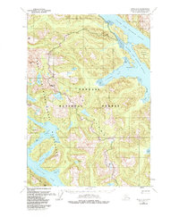
1951 Map of Sitka C-6
USGS Topo · Published 1984About this map
Chichagof Island reveals a complex network of deep coastal inlets and mountainous terrain in this 1951 survey, reflecting the maritime-dependent character of Southeast Alaska before modern development. The map details the intricate waterways of North Arm Hoonah Sound and South Arm Hoonah Sound, where Moser Island sits at the entrance to Douglas Bay. To the south, Slocum Arm and Khaaz Arm penetrate deep into the interior, separated from the open sea by the Takeena Peninsula.
Find a feature on this map
32 named features on this map. Tap any name to fly to it.
Don’t see what you’re looking for? This feature index may not catch every label — zoom into the map to look around manually.
Map Details
Editions of this 1951 Sitka C-6 Map
2 editions found

Other maps of this area

1948 · Sitka C-7
USGS Topo · 1:63,360

1948 · Sitka D-5
USGS Topo · 1:63,360

1948 · Sitka C-6
USGS Topo · 1:63,360

1948 · Sitka D-6
USGS Topo · 1:63,360

1948 · Sitka B-5
USGS Topo · 1:63,360

1951 · Sitka D-7
USGS Topo · 1:63,360

1951 · Sitka C-5
USGS Topo · 1:63,360

1951 · Sitka B-6
USGS Topo · 1:63,360

1951 · Sitka B-5
USGS Topo · 1:63,360

1951 · Sitka
USGS Topo · 1:250,000