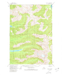
1951 Map of Sitka D-2
USGS Topo · Published 1980About this map
Admiralty Island National Monument dominates this mid-century topographic record, capturing the dense network of drainage systems and inland waters before modern conservation boundaries were further refined. The map reveals a remote landscape characterized by large freshwater bodies like Lake Florence and Lake Kathleen, which are linked to the coast by systems such as Fishery Creek and Wheeler Creek. A solitary Cabin situated on the northern shore of Lake Florence provides a rare trace of human presence, likely serving as a base for early biological studies or wilderness management. The inclusion of Swan Cove at the northeastern corner highlights the interface between the island's steep interior topography and the tidal flats of the surrounding waters. This survey documents the area's natural state just years after aerial photography began to modernize Alaska's cartographic record.
Find a feature on this map
10 named features on this map. Tap any name to fly to it.
Don’t see what you’re looking for? This feature index may not catch every label — zoom into the map to look around manually.
Map Details
Editions of this 1951 Sitka D-2 Map
2 editions found

Other maps of this area

1948 · Juneau A-3
USGS Topo · 1:63,360

1948 · Sitka D-1
USGS Topo · 1:63,360

1948 · Sitka C-2
USGS Topo · 1:63,360

1948 · Sitka C-3
USGS Topo · 1:63,360

1948 · Sitka D-3
USGS Topo · 1:63,360

1948 · Sitka D-2
USGS Topo · 1:63,360

1948 · Sitka C-1
USGS Topo · 1:63,360

1950 · Juneau A-3
USGS Topo · 1:63,360

1951 · Juneau
USGS Topo · 1:250,000

1951 · Juneau A-2
USGS Topo · 1:63,360