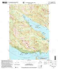
1997 Map of Sitka D-4
USGS Topo · Published 2000About this map
Chichagof Island serves as the backdrop for this late-century coastal survey, where the maritime and timber economies of Southeast Alaska intersect. Centered on the Tenakee Inlet and Freshwater Bay, the map documents a landscape defined by seasonal habitation and resource extraction. Evidence of the region's industrial past is visible at Cannery Ruins near Cannery Point, while the presence of a Logging Camp and several Cabins suggests active forest management and isolated outposts.
Find a feature on this map
64 named features on this map. Tap any name to fly to it.
Don’t see what you’re looking for? This feature index may not catch every label — zoom into the map to look around manually.
Map Details
Editions of this 1997 Sitka D-4 Map
This is the sole edition of this map. No revisions or reprints were ever made.
Other maps of this area

1948 · Juneau A-3
USGS Topo · 1:63,360

1948 · Juneau A-4
USGS Topo · 1:63,360

1948 · Sitka C-3
USGS Topo · 1:63,360

1948 · Sitka D-5
USGS Topo · 1:63,360

1948 · Sitka D-3
USGS Topo · 1:63,360

1948 · Sitka D-4
USGS Topo · 1:63,360

1950 · Juneau A-3
USGS Topo · 1:63,360

1951 · Juneau
USGS Topo · 1:250,000

1951 · Juneau A-5
USGS Topo · 1:63,360

1951 · Sitka C-5
USGS Topo · 1:63,360