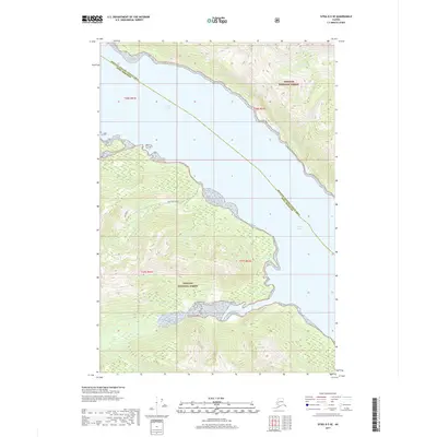
2017 Map of Sitka D-5 SE
USGS Topo · Published 2017About this map
Tongass National Forest dominates the coastal landscape of this Chichagof Island quadrangle, where steep forested slopes meet the cold waters of Southeast Alaska. The central geography is defined by the expanse of Tenakee Inlet, a critical waterway that separates the northern and southern landmasses shown here. Along the southern shore, Saltery Bay provides a protected indentation in the coastline, while the northern terrain is dissected by the Indian River. This 2017 survey reflects the enduring wilderness character of the region, emphasizing the maritime and glacial-carved topography that has shaped local navigation and resource use. The presence of Inbetween Creek and the administrative boundary of the Hoonah-Angoon Census Area Sitka Borough highlight the intersection of natural watersheds and modern jurisdictional lines in this remote coastal environment.
Find a feature on this map
11 named features on this map. Tap any name to fly to it.
Don’t see what you’re looking for? This feature index may not catch every label — zoom into the map to look around manually.
Map Details
Editions of this 2017 Sitka D-5 SE Map
This is the sole edition of this map. No revisions or reprints were ever made.
Other maps of this area

1948 · Sitka D-5
USGS Topo · 1:63,360

1948 · Sitka D-4
USGS Topo · 1:63,360

1951 · Sitka C-5
USGS Topo · 1:63,360

1951 · Sitka C-4
USGS Topo · 1:63,360

1951 · Sitka
USGS Topo · 1:250,000

1951 · Sitka D-5
USGS Topo · 1:63,360

1952 · Sitka
USGS Topo · 1:250,000

1955 · Sitka D-4
USGS Topo · 1:63,360

1964 · Sitka
USGS Topo · 1:250,000
1997 · Sitka D-4
USGS Topo · 1:63,360