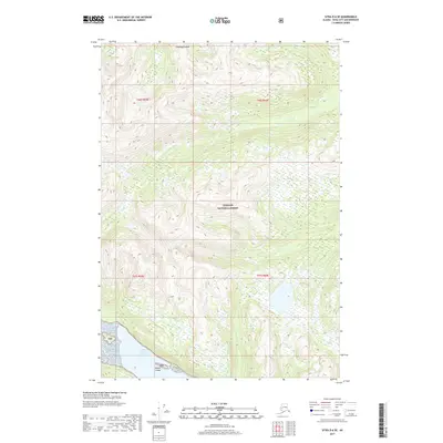
2017 Map of Sitka D-6 SE
USGS Topo · Published 2017About this map
Chichagof Island dominates this 2017 survey, revealing a landscape defined by the expansive Tongass National Forest. The map documents the intricate coastal interface where the rugged interior meets North Arm Hoonah Sound. Topography here is exceptionally steep, with elevation contours rising sharply from the saltwater to peaks exceeding 2,800 feet. The southeastern corner features Nelson Island, a small landmass separated from the primary island by narrow channels. Aside from the administrative markers of the TNF, the area is devoid of modern infrastructure, showing the undisturbed character of the Alexander Archipelago. This data, compiled from recent GNIS and National Hydrography Dataset sources, provides an essential record of the shoreline and elevation patterns in a region where the forest and the sea are the only prominent features.
Find a feature on this map
9 named features on this map. Tap any name to fly to it.
Don’t see what you’re looking for? This feature index may not catch every label — zoom into the map to look around manually.
Map Details
Editions of this 2017 Sitka D-6 SE Map
This is the sole edition of this map. No revisions or reprints were ever made.
Other maps of this area

1948 · Sitka D-5
USGS Topo · 1:63,360

1948 · Sitka C-6
USGS Topo · 1:63,360

1948 · Sitka D-6
USGS Topo · 1:63,360

1951 · Sitka C-5
USGS Topo · 1:63,360

1951 · Sitka
USGS Topo · 1:250,000

1951 · Sitka C-6
USGS Topo · 1:63,360

1951 · Sitka D-6
USGS Topo · 1:63,360

1951 · Sitka D-5
USGS Topo · 1:63,360

1952 · Sitka
USGS Topo · 1:250,000

1964 · Sitka
USGS Topo · 1:250,000