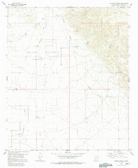
1980 Map of Sixteen Canyon
USGS Topo · Published 1992About this map
The Fort Bliss Military Reservation (McGregor Range) dominates this high-desert landscape of Otero County, where topography dictates the patterns of life and movement. The Sacramento River and its accompanying drainage systems, including Sixteen Canyon and Seventeen Canyon, reveal the complex erosion patterns common to this arid region. For researchers, the presence of the Prather Ranch and a nearby isolated Grave south of the township line provides evidence of early ranching families who carved out an existence before the expansion of the military range. Human infrastructure is primarily focused on water management for livestock and survival, as seen in named water sources such as Shipment Tank, Chess Tank, and Trammel Well. The map illustrates the 1970s landscape of South-Central New Mexico, showing the intersection of private agricultural history and national defense requirements.
Find a feature on this map
20 named features on this map. Tap any name to fly to it.
Don’t see what you’re looking for? This feature index may not catch every label — zoom into the map to look around manually.
Map Details
Editions of this 1980 Sixteen Canyon Map
2 editions found
Other maps of this area

1954 · Carlsbad
USGS Topo · 1:250,000

1958 · Carlsbad
USGS Topo · 1:250,000

1963 · Indian Draw
USGS Topo · 1:24,000

1963 · Cleones Tank
USGS Topo · 1:24,000

1965 · Surveyors Canyon
USGS Topo · 1:24,000

1965 · El Paso Canyon
USGS Topo · 1:24,000

1965 · Pinon
USGS Topo · 1:24,000

1979 · Alamogordo
USGS Topo · 1:100,000

1979 · Crow Flats
USGS Topo · 1:100,000
1980 · El Paso Draw
USGS Topo · 1:24,000