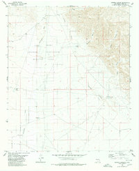
1980 Map of Sixteen Canyon
USGS Topo · Published 1980About this map
Fort Bliss Military Reservation (McGregor Range) dominates the northern and central sections of this landscape, marking a transition from public lands to restricted military training grounds in Otero County. The desert terrain is defined by the ephemeral Sacramento River and a series of deep drainages including Chatfield Canyon, Seventeen Canyon, and Sixteen Canyon. These natural corridors dictate the movement of water and travelers through the arid environment.
Find a feature on this map
18 named features on this map. Tap any name to fly to it.
Don’t see what you’re looking for? This feature index may not catch every label — zoom into the map to look around manually.
Map Details
Editions of this 1980 Sixteen Canyon Map
2 editions found
Other maps of this area

1954 · Carlsbad
USGS Topo · 1:250,000

1958 · Carlsbad
USGS Topo · 1:250,000

1963 · Indian Draw
USGS Topo · 1:24,000

1963 · Cleones Tank
USGS Topo · 1:24,000

1965 · Surveyors Canyon
USGS Topo · 1:24,000

1965 · El Paso Canyon
USGS Topo · 1:24,000

1965 · Pinon
USGS Topo · 1:24,000

1979 · Alamogordo
USGS Topo · 1:100,000

1979 · Crow Flats
USGS Topo · 1:100,000
1980 · El Paso Draw
USGS Topo · 1:24,000