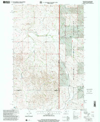
1997 Map of Skaar NE
USGS Topo · Published 2001About this map
The Little Missouri National Grassland dominates the eastern half of this landscape, where the rugged drainages of Spring Creek and Poison Creek define the topography along the Montana and North Dakota border. This late twentieth-century revision reveals a rural economy centered on established family holdings such as the Thompson Ranch and Kupper Ranch. Community life is anchored by landmarks like the Shadwell Sch and Grace Ch, providing essential reference points for genealogists tracing family roots in this corner of Richland County.
Find a feature on this map
16 named features on this map. Tap any name to fly to it.
Don’t see what you’re looking for? This feature index may not catch every label — zoom into the map to look around manually.
Map Details
Editions of this 1997 Skaar NE Map
This is the sole edition of this map. No revisions or reprints were ever made.
Other maps of this area

1909 · Glendive
USGS Topo · 1:250,000

1953 · Watford City
USGS Topo · 1:250,000

1954 · Glendive
USGS Topo · 1:250,000

1957 · Glendive
USGS Topo · 1:250,000

1957 · Watford City
USGS Topo · 1:250,000

1958 · Glendive
USGS Topo · 1:250,000

1966 · Piche
USGS Topo · 1:24,000

1966 · Skaar NW
USGS Topo · 1:24,000

1967 · Watford City
USGS Topo · 1:250,000

1972 · Sidney SE
USGS Topo · 1:24,000