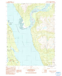
1991 Map of Skagway A-1 NW
USGS Topo · Published 1991About this map
The Chilkoot Peninsula dominates this 1991 provisional map, separating the waters of the Chilkoot Inlet and the silt-laden mouth of the Katzehin River. This coastal landscape is defined by the intersection of the Chilkat State Park and the Tongass National Forest, where steep terrain meets the tides. A single terrestrial artery, Mud Bay Road, provides access to the southern peninsula, while a remote Landing Strip and the Pack Trail suggest the limited infrastructure of this Alaskan wilderness at the time of photography. Smaller water bodies like Paradise Lake and Rutzebeck Lake are tucked into the drainages of the Katz and Katzehin mountains. The map also records early land divisions through numerous U S Survey boundary markers that intersect the parkland and forest.
Find a feature on this map
27 named features on this map. Tap any name to fly to it.
Don’t see what you’re looking for? This feature index may not catch every label — zoom into the map to look around manually.
Map Details
Editions of this 1991 Skagway A-1 NW Map
This is the sole edition of this map. No revisions or reprints were ever made.
Other maps of this area

1948 · Skagway A-1
USGS Topo · 1:63,360

1949 · Skagway B-1
USGS Topo · 1:63,360

1951 · Skagway A-1
USGS Topo · 1:63,360

1951 · Skagway B-1
USGS Topo · 1:63,360

1952 · Skagway
USGS Topo · 1:250,000

1954 · Skagway B-2
USGS Topo · 1:63,360

1954 · Skagway A-2
USGS Topo · 1:63,360

1961 · Skagway
USGS Topo · 1:250,000
1991 · Skagway B-2 SE
USGS Topo · 1:25,000
1991 · Skagway B-1 SW
USGS Topo · 1:25,000