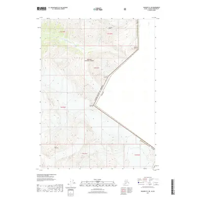
2017 Map of Skagway B-1 NE
USGS Topo · Published 2017About this map
The United States and Canada international border bisects this high-elevation landscape within the Coast Mountains. This 2017 survey details a remote section of the Alaska Skagway Municipality where the Sawtooth Range dominates the northern horizon. The upper reaches of the East Fork Skagway River flow through the deep glacial valleys of the Tongass National Forest, illustrating the hydrological patterns of the northern Pacific coast. Prominent surveyor landmarks define the jagged frontier, including the heights of Mt Hefty and key survey markers like Boundary Peak 111 and Boundary Peak 109, which mark the geopolitical divide between the Alaskan wilderness and British Columbia.
Find a feature on this map
18 named features on this map. Tap any name to fly to it.
Don’t see what you’re looking for? This feature index may not catch every label — zoom into the map to look around manually.
Map Details
Editions of this 2017 Skagway B-1 NE Map
This is the sole edition of this map. No revisions or reprints were ever made.
Other maps of this area

1948 · Skagway C-1
USGS Topo · 1:63,360

1949 · Atlin
USGS Topo · 1:250,000

1949 · Skagway B-1
USGS Topo · 1:63,360

1951 · Skagway C-1
USGS Topo · 1:63,360

1951 · Atlin
USGS Topo · 1:250,000

1951 · Skagway B-1
USGS Topo · 1:63,360

1952 · Skagway
USGS Topo · 1:250,000
1960 · Atlin B-8
USGS Topo · 1:63,360

1960 · Atlin
USGS Topo · 1:250,000

1961 · Skagway
USGS Topo · 1:250,000