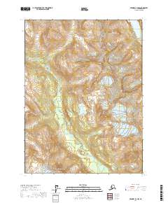
2017 Map of Skagway B-2 NW
USGS Topo · Published 2017About this map
The Chilkoot River winds through this mountainous section of the Alaska-Haines Borough, cutting a path through township lines T27S, T28S, and T29S. The landscape is defined by significant elevations, including the prominent Mt Kashagnak in the southern reaches and the peak of Ziskokadlo to the east. This 2017 survey illustrates the intricate drainage patterns of the region, where high-altitude water bodies like Connolly Lake are situated amidst a complex network of ridgelines and slopes. The map reveals the isolation of these interior Alaskan features, providing precise topographic data for the river's upper course and the surrounding peaks before they descend toward the coastal corridors.
Find a feature on this map
10 named features on this map. Tap any name to fly to it.
Don’t see what you’re looking for? This feature index may not catch every label — zoom into the map to look around manually.
Map Details
Editions of this 2017 Skagway B-2 NW Map
This is the sole edition of this map. No revisions or reprints were ever made.
Other maps of this area

1948 · Skagway C-3
USGS Topo · 1:63,360

1948 · Skagway C-2
USGS Topo · 1:63,360

1951 · Skagway C-2
USGS Topo · 1:63,360

1952 · Skagway
USGS Topo · 1:250,000

1954 · Skagway B-2
USGS Topo · 1:63,360

1954 · Skagway B-3
USGS Topo · 1:63,360
1954 · Skagway C-3
USGS Topo · 1:63,360

1961 · Skagway
USGS Topo · 1:250,000
1991 · Skagway B-2 SW
USGS Topo · 1:25,000
1991 · Skagway B-3 NE
USGS Topo · 1:25,000