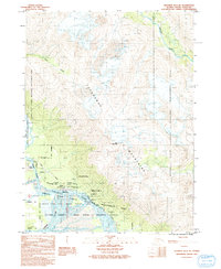
1991 Map of Skagway B-3 NE
USGS Topo · Published 1991About this map
Klukwan sits at the vital confluence where the Klehini River and Tsirku River meet the Chilkat River, serving as a central point of settlement in this northern Alaska landscape. The 1991 provisional survey documents the intricate river systems and mountain peaks, including the prominent Takshanuk Mountains and Iron Mountain. Land management is a primary focus of this record, detailing the extensive Alaska Chilkat Bald Eagle Preserve (State) and the Haines State Forest Resource Management Area. The map reveals local infrastructure such as the Klukwan Highway and the crossing at Wells Bridge near the small settlement of Wells. Genealogists and historians can identify localized markers including a Cem and specific land survey boundaries like Haines Borough Indian US Survey 33, reflecting the complex overlay of tribal, state, and federal land interests in the borough.
Find a feature on this map
24 named features on this map. Tap any name to fly to it.
Don’t see what you’re looking for? This feature index may not catch every label — zoom into the map to look around manually.
Map Details
Editions of this 1991 Skagway B-3 NE Map
This is the sole edition of this map. No revisions or reprints were ever made.
Other maps of this area

1948 · Skagway C-3
USGS Topo · 1:63,360

1948 · Skagway C-2
USGS Topo · 1:63,360

1951 · Skagway C-2
USGS Topo · 1:63,360

1952 · Skagway
USGS Topo · 1:250,000

1954 · Skagway B-2
USGS Topo · 1:63,360

1954 · Skagway B-3
USGS Topo · 1:63,360
1954 · Skagway C-3
USGS Topo · 1:63,360

1961 · Skagway
USGS Topo · 1:250,000
1991 · Skagway B-3 SW
USGS Topo · 1:25,000
1991 · Skagway B-3 NW
USGS Topo · 1:25,000