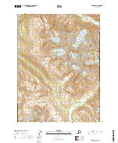
2017 Map of Skagway C-3 SE
USGS Topo · Published 2017About this map
Takshanuk Mountains define the high-elevation interior of this region within the Haines Borough. This landscape is marked by extreme relief and glacial topography, dominated by the peaks of Klukwah Mtn and Klutshah Mtn. Mapping in the 21st century highlights the persistence of these massive geological formations in one of the more inaccessible reaches of southeast Alaska. The absence of roads, settlements, or structures emphasizes the wilderness character of the terrain, where the only human-defined markers are the surveying boundaries for t26s r56e and surrounding townships. This 2017 survey provides a precise modern baseline for tracking glacial recession and geological shifts in the high peaks north of the coastal inlets.
Find a feature on this map
7 named features on this map. Tap any name to fly to it.
Don’t see what you’re looking for? This feature index may not catch every label — zoom into the map to look around manually.
Map Details
Editions of this 2017 Skagway C-3 SE Map
This is the sole edition of this map. No revisions or reprints were ever made.
Other maps of this area

1948 · Skagway C-3
USGS Topo · 1:63,360

1948 · Skagway C-2
USGS Topo · 1:63,360

1951 · Skagway C-2
USGS Topo · 1:63,360

1952 · Skagway
USGS Topo · 1:250,000

1954 · Skagway B-2
USGS Topo · 1:63,360

1954 · Skagway B-3
USGS Topo · 1:63,360
1954 · Skagway C-3
USGS Topo · 1:63,360

1961 · Skagway
USGS Topo · 1:250,000
1991 · Skagway B-3 NW
USGS Topo · 1:25,000
1991 · Skagway B-3 NE
USGS Topo · 1:25,000