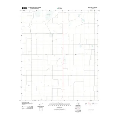
2010 Map of Skeen Lake
USGS Topo · Published 2010About this map
Guthrie Lake and its smaller counterpart, Skeen Lake, dominate the arid landscape of the Texas South Plains in this early 21st-century survey. The settlement of Skeen sits at the intersection of a vast grid of section roads and farm-to-market routes, reflecting the intensive agricultural layout of Lynn County. The terrain is defined by these large playa lakes, which serve as critical drainage points in a region of low relief. A dense network of county roads, including Sam Rd and Co Rd V, partitions the land into precise rectangles, highlighting the dominance of cotton and grain farming. This map provides a clear record of the rural infrastructure as it stood before modern changes, documenting the exact placement of local routes like Fm 3332 and Fm 213.
Find a feature on this map
17 named features on this map. Tap any name to fly to it.
Don’t see what you’re looking for? This feature index may not catch every label — zoom into the map to look around manually.
Map Details
Editions of this 2010 Skeen Lake Map
This is the sole edition of this map. No revisions or reprints were ever made.
Other maps of this area

1954 · Lubbock
USGS Topo · 1:250,000

1954 · Big Spring
USGS Topo · 1:250,000

1958 · Big Spring
USGS Topo · 1:250,000

1969 · Skeen Lake
USGS Topo · 1:24,000

1969 · Gooch Lake
USGS Topo · 1:24,000

1969 · O'Donnell
USGS Topo · 1:24,000

1969 · Tahoka
USGS Topo · 1:24,000
1969 · Tahoka SW
USGS Topo · 1:24,000

1969 · Double Lakes
USGS Topo · 1:24,000

1970 · New Lynn
USGS Topo · 1:24,000