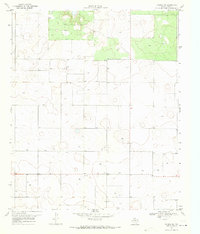
1969 Map of Tahoka SW
USGS Topo · Published 1971About this map
Wells Ch and numerous scattered Wells define the agricultural landscape of this corner of Lynn County in the late 1960s. The terrain is characterized by a high density of depressions and seasonal water features, common in the Llano Estacado, which dictated the placement of local infrastructure and dwellings. The sheer volume of individual Well and Wells labels across the sheet illustrates the critical importance of groundwater management for the rural Texas High Plains during this era. This 1969 survey, produced in cooperation with the State of Texas Water Development Board, serves as a high-resolution record of the region's hydrography and rural community structure before modern irrigation and development altered many of these original landmarks.
Find a feature on this map
4 named features on this map. Tap any name to fly to it.
Don’t see what you’re looking for? This feature index may not catch every label — zoom into the map to look around manually.
Map Details
Editions of this 1969 Tahoka SW Map
This is the sole edition of this map. No revisions or reprints were ever made.
Other maps of this area

1954 · Lubbock
USGS Topo · 1:250,000

1954 · Hobbs
USGS Topo · 1:250,000

1954 · Big Spring
USGS Topo · 1:250,000

1954 · Brownfield
USGS Topo · 1:250,000

1958 · Brownfield
USGS Topo · 1:250,000

1958 · Big Spring
USGS Topo · 1:250,000

1958 · Hobbs
USGS Topo · 1:250,000

1962 · Brownfield
USGS Topo · 1:250,000

1969 · Welch East
USGS Topo · 1:24,000

1969 · Mound Lake
USGS Topo · 1:24,000