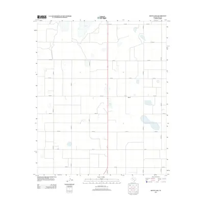
2012 Map of Skeen Lake
USGS Topo · Published 2012About this map
Skeen sits at the heart of this Southern High Plains landscape, a small community defined by its proximity to the shallow catchment of Skeen Lake. This 2012 survey by the U.S. Geological Survey shows a strictly gridded road network, where local routes like Co Rd 321 and Co Rd 331 provide access to the vast agricultural sections of Lynn County. The terrain is dotted with seasonal water bodies, including the larger Guthrie Lake to the north and numerous smaller depressions that characterize this portion of the Llano Estacado. Movement through the area is facilitated by state-maintained farm-to-market roads, specifically FM 3332 and FM 213, which connect the rural homesteads and cotton fields to larger regional hubs. The geography here is a classic example of Texas panhandle land management, where the geometric precision of the county roads contrasts with the irregular, natural forms of the local basins.
Find a feature on this map
24 named features on this map. Tap any name to fly to it.
Don’t see what you’re looking for? This feature index may not catch every label — zoom into the map to look around manually.
Map Details
Editions of this 2012 Skeen Lake Map
This is the sole edition of this map. No revisions or reprints were ever made.
Other maps of this area

1954 · Lubbock
USGS Topo · 1:250,000

1954 · Big Spring
USGS Topo · 1:250,000

1958 · Big Spring
USGS Topo · 1:250,000

1969 · Skeen Lake
USGS Topo · 1:24,000

1969 · Gooch Lake
USGS Topo · 1:24,000

1969 · O'Donnell
USGS Topo · 1:24,000

1969 · Tahoka
USGS Topo · 1:24,000
1969 · Tahoka SW
USGS Topo · 1:24,000

1969 · Double Lakes
USGS Topo · 1:24,000

1970 · New Lynn
USGS Topo · 1:24,000