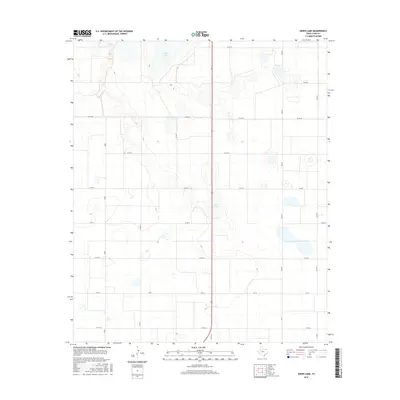
2016 Map of Skeen Lake
USGS Topo · Published 2016About this map
Guthrie Lake and Skeen Lake serve as the primary natural landmarks in this portion of Lynn County, marking a landscape defined by shallow depressions and an extensive network of rural corridors. The region is bisected north to south by Highway 87, a major arterial route that connects the agricultural parcels and ranch lands of the Texas South Plains. A grid of county roads, including Co Rd 28 and Co Rd 32, reflects the systematic division of the land for agricultural use. Farm-to-market roads like Fm 213 and Fm 3332 facilitate movement between these rural sections, highlighting the transport-heavy nature of local industry. This 2016 survey captures the area's modern infrastructure while preserving the same spatial layout used by generations of West Texas farmers.
Find a feature on this map
13 named features on this map. Tap any name to fly to it.
Don’t see what you’re looking for? This feature index may not catch every label — zoom into the map to look around manually.
Map Details
Editions of this 2016 Skeen Lake Map
This is the sole edition of this map. No revisions or reprints were ever made.
Other maps of this area

1954 · Lubbock
USGS Topo · 1:250,000

1954 · Big Spring
USGS Topo · 1:250,000

1958 · Big Spring
USGS Topo · 1:250,000

1969 · Skeen Lake
USGS Topo · 1:24,000

1969 · Gooch Lake
USGS Topo · 1:24,000

1969 · O'Donnell
USGS Topo · 1:24,000

1969 · Tahoka
USGS Topo · 1:24,000
1969 · Tahoka SW
USGS Topo · 1:24,000

1969 · Double Lakes
USGS Topo · 1:24,000

1970 · New Lynn
USGS Topo · 1:24,000