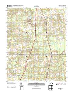
2013 Map of Skippers
USGS Topo · Published 2013About this map
Skippers and the surrounding crossroads communities of Greensville County sit at the border of Virginia and North Carolina in this 2013 survey. The landscape is defined by an intricate network of wetlands and drainage systems, including Jacks Swamp, Caney Swamp, and Mill Swamp, which hem in the local agriculture and timber lands. Historical nodes of local commerce and social life are marked at Mitchells Mill, Dahlia, and Pleasant Hill, points that have long anchored this rural borderland region. The mapping detail highlights how contemporary transportation corridors, such as the Hollyhock Trl bypass, cut through the older patterns of settlement. For those looking for recreational or property markers, features like the Cattail Creek Campground and numerous family-named roads provide precise geographic anchors for the modern era.
Find a feature on this map
58 named features on this map. Tap any name to fly to it.
Don’t see what you’re looking for? This feature index may not catch every label — zoom into the map to look around manually.
Map Details
Editions of this 2013 Skippers Map
This is the sole edition of this map. No revisions or reprints were ever made.
Other maps of this area

1919 · Emporia
USGS Topo · 1:62,500

1919 · Arringdale
USGS Topo · 1:48,000

1920 · Arringdale
USGS Topo · 1:62,500

1942 · Arringdale
USGS Topo · 1:62,500

1942 · Emporia
USGS Topo · 1:62,500

1953 · Norfolk
USGS Topo · 1:250,000

1963 · Skippers
USGS Topo · 1:24,000

1963 · Barley
USGS Topo · 1:24,000

1963 · Emporia
USGS Topo · 1:24,000

1963 · Ante
USGS Topo · 1:24,000