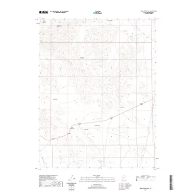
2020 Map of Skull Rock Pass
USGS Topo · Published 2020About this map
The House Range dominates this portion of Millard County, creating a formidable geological barrier defined by significant elevation changes and seasonal drainage basins. Travel through this arid landscape is funneled through natural gaps such as Skull Rock Pass and the higher Sneakover Pass, which provide passage between the surrounding lowlands. The nomenclature of the area reflects the difficulty of the terrain, with evocative names like Hell'n Moriah Canyon and its associated Hell'n Moriah Kitchen in the northwest, alongside distinctive landmarks like Skull Rock and the tiered formations of The Stairs. Aside from the primary route of Tule Valley Rd and a few secondary roads, the region remains largely undeveloped, characterized by vast basins like Sawtooth Cove and Little Valley that emphasize the isolated nature of the Great Basin geography.
Find a feature on this map
13 named features on this map. Tap any name to fly to it.
Don’t see what you’re looking for? This feature index may not catch every label — zoom into the map to look around manually.
Map Details
Editions of this 2020 Skull Rock Pass Map
This is the sole edition of this map. No revisions or reprints were ever made.
Other maps of this area

1908 · Fish Springs
USGS Topo · 1:250,000

1910 · Fish Springs
USGS Topo · 1:250,000

1953 · Richfield
USGS Topo · 1:250,000

1953 · Delta
USGS Topo · 1:250,000

1958 · Richfield
USGS Topo · 1:250,000

1958 · Delta
USGS Topo · 1:250,000

1960 · Notch Peak
USGS Topo · 1:62,500

1960 · The Barn
USGS Topo · 1:62,500

1962 · Delta
USGS Topo · 1:250,000
1972 · Needle Point
USGS Topo · 1:24,000