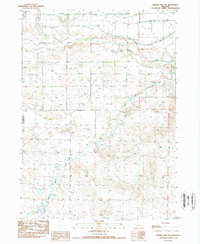
1989 Map of Skunk Lake NW
USGS Topo · Published 1989About this map
The Niobrara River winds across the northern reaches of this landscape, carving a distinct valley through the Nebraska High Plains. This 1989 provisional study documents an era of managed water resources in the Nebraska Panhandle, specifically within the Sheridan Co and Box Butte Co borderlands. The intricate network of irrigation is visible through the Sturgeon Canal and multiple branches of the Lateral system and Drain lines, which divert water from the river to support local agriculture. The terrain shifts from the river valley to the winding path of Box Butte Creek in the south, reflecting a landscape defined by its hydrology and small-scale resource extraction, such as the isolated Gravel Pit.
Find a feature on this map
9 named features on this map. Tap any name to fly to it.
Don’t see what you’re looking for? This feature index may not catch every label — zoom into the map to look around manually.
Map Details
Editions of this 1989 Skunk Lake NW Map
This is the sole edition of this map. No revisions or reprints were ever made.
Other maps of this area

1947 · Box Butte NE
USGS Topo · 1:24,000

1947 · Box Butte
USGS Topo · 1:24,000

1949 · Box Butte NE
USGS Topo · 1:24,000

1949 · Box Butte
USGS Topo · 1:24,000

1950 · Skunk Lake
USGS Topo · 1:62,500

1955 · Alliance
USGS Topo · 1:250,000

1957 · Alliance
USGS Topo · 1:250,000

1958 · Alliance
USGS Topo · 1:250,000

1960 · Hay Springs SW
USGS Topo · 1:24,000

1960 · Hay Springs SE
USGS Topo · 1:24,000