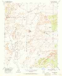
1954 Map of Sky Village
USGS Topo · Published 1969About this map
Sky Village (Ruins) sits atop the prominent San Felipe Mesa, overlooking a landscape defined by historic land grants and the winding course of the Rio Puerco. This mid-century survey illustrates the complex jurisdictional boundaries of central New Mexico, where the Laguna Indian Reservation meets the Montano Grant. The presence of several established ranching outposts, such as Collier Ranch, Sandoval Ranch, and Alamo Ranch, points to a cattle-based economy reliant on scattered water sources like Sandoval Spring and various stock tanks. Remnants of earlier habitation are visible at San Francisco (Ruins) along the river. The terrain is deeply incised by drainage systems, including Arroyo Bernardo and Arroyo Alamo, which cut through the Benavidez area, reflecting the arid environment's influence on settlement patterns and movement during this era.
Find a feature on this map
26 named features on this map. Tap any name to fly to it.
Don’t see what you’re looking for? This feature index may not catch every label — zoom into the map to look around manually.
Map Details
Editions of this 1954 Sky Village Map
Other maps of this area

1883 · Mt. Taylor
USGS Topo · 1:250,000

1886 · Mt. Taylor
USGS Topo · 1:250,000

1888 · Bernalillo
USGS Topo · 1:125,000

1889 · Albuquerque
USGS Topo · 1:125,000

1892 · Mt. Taylor
USGS Topo · 1:250,000

1893 · Albuquerque
USGS Topo · 1:125,000

1899 · Mt. Taylor
USGS Topo · 1:250,000

1954 · Herrera
USGS Topo · 1:24,000

1954 · Volcano Ranch
USGS Topo · 1:24,000

1954 · Sky Village
USGS Topo · 1:24,000