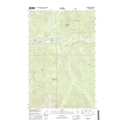
2017 Map of Skykomish
USGS Topo · Published 2017About this map
Skykomish serves as the central hub of this mountain landscape, positioned where the BNSF Railway and W Old Cascade Hwy parallel the South Fork Skykomish River. The map highlights the transit infrastructure essential to the region, including the Skykomish State Airport and the South Fork Skykomish River Bridge. Beyond the settlement, the Snoqualmie National Forest dominates the terrain, defined by significant elevations like Sobieski Mtn and Beckler Peak. Water is a defining element throughout the quadrangle, from the larger flows of the Beckler River and Tye River to the high-elevation clusters of Maloney Lakes and Panorama Lake. The intricate network of Forest Service roads, such as Nat For Dev Rd 65 and Foss River Rd NE, illustrates the deep integration of forestry and recreation within these peaks and ridges.
Find a feature on this map
52 named features on this map. Tap any name to fly to it.
Don’t see what you’re looking for? This feature index may not catch every label — zoom into the map to look around manually.
Map Details
Editions of this 2017 Skykomish Map
This is the sole edition of this map. No revisions or reprints were ever made.
Other maps of this area

1902 · Skykomish
USGS Topo · 1:125,000

1905 · Skykomish
USGS Topo · 1:125,000

1957 · Wenatchee
USGS Topo · 1:250,000

1965 · Captain Point
USGS Topo · 1:24,000

1965 · Evergreen Mtn
USGS Topo · 1:24,000

1965 · Grotto
USGS Topo · 1:24,000

1965 · Mount Daniel
USGS Topo · 1:24,000

1965 · Skykomish
USGS Topo · 1:24,000
1965 · Baring
USGS Topo · 1:24,000
1965 · Snoqualmie Lake
USGS Topo · 1:24,000