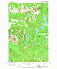
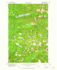
1965 Map of Snoqualmie Lake
USGS Topo · Published 1967About this map
Snoqualmie National Forest defines the character of this mid-1960s terrain, dominated by the high-elevation drainage basins of the Taylor River and the Miller River. The map meticulously records the numerous alpine water bodies that sit within these steep watersheds, including the expansive Lake Dorothy and the clustered Snoqualmie Lake Potholes. This era of the landscape is characterized by its reliance on a network of trails rather than roads for deep access, as seen with the Pack Trail and Dingford Creek Trail winding through the peaks. Significant landmarks like Garfield Mtn and Mt Price provide the vertical relief for a wilderness that remains largely unchanged by industrial footprint, focused instead on the preservation of the Middle Fork Snoqualmie River headwaters. Notable natural features like Otter Falls near Lipsy Lake highlight the dramatic water runoff patterns inherent to this part of the Cascades.
Find a feature on this map
62 named features on this map. Tap any name to fly to it.
Don’t see what you’re looking for? This feature index may not catch every label — zoom into the map to look around manually.
Map Details
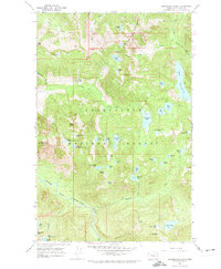
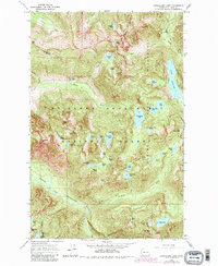
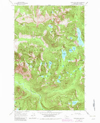
Editions of this 1965 Snoqualmie Lake Map
4 editions found
Other maps of this area

1901 · Snoqualmie Pass
USGS Topo · 1:125,000

1902 · Skykomish
USGS Topo · 1:125,000

1903 · Snoqualmie
USGS Topo · 1:125,000

1905 · Skykomish
USGS Topo · 1:125,000

1913 · Cedar Lake
USGS Topo · 1:125,000

1921 · Sultan
USGS Topo · 1:125,000

1923 · Sultan
USGS Topo · 1:125,000

1957 · Wenatchee
USGS Topo · 1:250,000
1960 · Mount Si
USGS Topo · 1:62,500
1960 · Bandera
USGS Topo · 1:62,500