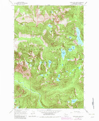
1965 Map of Snoqualmie Lake
USGS Topo · Published 1982About this map
Mt Baker Snoqualmie National Forest dominates this landscape, defined by a dense concentration of high-elevation water bodies and drainage systems. The Lake Dorothy basin is the most prominent feature in the eastern section, while Snoqualmie Lake serves as a central landmark for the surrounding peaks. The transition of water through the terrain is marked by distinctive features such as Otter Falls and the Snoqualmie Lake Potholes.
Find a feature on this map
55 named features on this map. Tap any name to fly to it.
Don’t see what you’re looking for? This feature index may not catch every label — zoom into the map to look around manually.
Map Details
Editions of this 1965 Snoqualmie Lake Map
4 editions found
Other maps of this area

1901 · Snoqualmie Pass
USGS Topo · 1:125,000

1902 · Skykomish
USGS Topo · 1:125,000

1903 · Snoqualmie
USGS Topo · 1:125,000

1905 · Skykomish
USGS Topo · 1:125,000

1913 · Cedar Lake
USGS Topo · 1:125,000

1921 · Sultan
USGS Topo · 1:125,000

1923 · Sultan
USGS Topo · 1:125,000

1957 · Wenatchee
USGS Topo · 1:250,000

1960 · Mount Si
USGS Topo · 1:62,500

1960 · Bandera
USGS Topo · 1:62,500