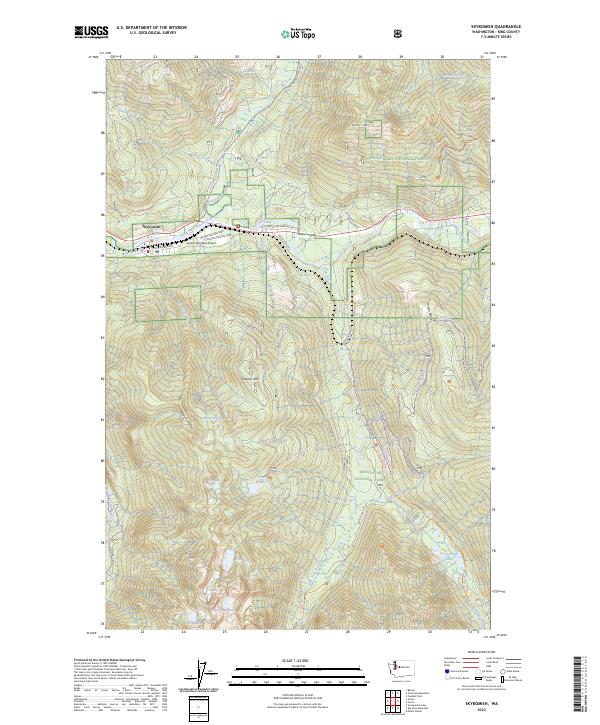
2023 Map of Skykomish
USGS Topo · Published 2023About this map
Skykomish occupies a narrow shelf of the valley floor where the Beckler River and the South Fork Skykomish River converge. This mountain settlement is defined by its position along the NE Old Cascade Hwy, which traces the contours of the river valley. The surrounding landscape is characterized by high alpine topography, including prominent summits like Beckler Peak and Sobieski Mtn. Large tracts of protected land, such as the Snoqualmie National Forest, Wild Sky Wilderness, and Alpine Lakes Wilderness, dominate the area, revealing a vast network of backcountry trails and forest service roads. Genealogists and local historians can trace the paths of the Necklace Valley Trl and Tonga Ridge Road Trl leading into the high country. Numerous remote water bodies, including Maloney Lakes, Evans Lake, and Panorama Lake, are tucked between ridges like Maloney Ridge and Tonga Ridge, highlighting the region's wilderness character and glacial history.
Find a feature on this map
56 named features on this map. Tap any name to fly to it.
Don’t see what you’re looking for? This feature index may not catch every label — zoom into the map to look around manually.
Map Details
Editions of this 2023 Skykomish Map
This is the sole edition of this map. No revisions or reprints were ever made.
Other maps of this area

1902 · Skykomish
USGS Topo · 1:125,000

1905 · Skykomish
USGS Topo · 1:125,000

1957 · Wenatchee
USGS Topo · 1:250,000

1965 · Captain Point
USGS Topo · 1:24,000

1965 · Evergreen Mtn
USGS Topo · 1:24,000

1965 · Grotto
USGS Topo · 1:24,000

1965 · Mount Daniel
USGS Topo · 1:24,000

1965 · Skykomish
USGS Topo · 1:24,000
1965 · Baring
USGS Topo · 1:24,000
1965 · Snoqualmie Lake
USGS Topo · 1:24,000