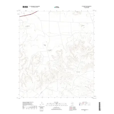
2019 Map of Skyscraper Peak
USGS Topo · Published 2019About this map
Skyscraper Peak stands as the central landmark in this high-relief corridor of Pecos County, where the southern plains of West Texas meet significant mesa formations. The landscape is defined by its topographic extremes, transitioning from the broad elevations of Big Mesa and Little Mesa in the north to the deeply incised drainages of Harral Draw in the south. The mapping reveals a sparse transportation network dominated by Trans Pecos Rd and the I10 Svc Rd, reflecting the large-scale ranching and land-management patterns typical of this trans-Pecos region. Smaller summits like Darrels Peak and Big Baldy Peak punctuate the ridges, while the extensive McKenzie Mesa anchors the southeastern quadrant, illustrating the erosion patterns of the Edwards Plateau's western edge.
Find a feature on this map
10 named features on this map. Tap any name to fly to it.
Don’t see what you’re looking for? This feature index may not catch every label — zoom into the map to look around manually.
Map Details
Editions of this 2019 Skyscraper Peak Map
This is the sole edition of this map. No revisions or reprints were ever made.
Other maps of this area

1928 · Comanche Spring
USGS Topo · 1:125,000

1929 · Independence Draw Quadrangle
USGS Topo · 1:125,000

1954 · Fort Stockton
USGS Topo · 1:250,000

1958 · Fort Stockton
USGS Topo · 1:250,000

1969 · Bootleg Canyon
USGS Topo · 1:24,000

1969 · Skyscraper Peak
USGS Topo · 1:24,000

1969 · Hackberry Draw NW
USGS Topo · 1:24,000

1969 · Hackberry Draw NE
USGS Topo · 1:24,000

1969 · Bakersfield
USGS Topo · 1:24,000
1969 · Sherbino Mesa
USGS Topo · 1:24,000