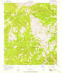
1954 Map of Slagle
USGS Topo · Published 1958About this map
The Fort Polk Military Reservation dominates the southern landscape of this Vernon Parish survey, where military infrastructure meets the rural settlement of Slagle. Grounded in data from 1953 aerial photography, the map reveals a transition from agricultural land to defense grounds, including the North Fort Polk area. The interior is marked by several small rural congregations, including Mt Bethel Church, Mt Zion Church, and Antioch Church, alongside family burial grounds like Self Cemetery and Smart Cemetery. Traces of the region's earlier industrial logging era are visible through several stretches of Dismantled railroad that once serviced the timber industry. Natural drainage is defined by the winding paths of Bayou Castor and Liberty Creek, which feed into Castor Lake, illustrating the complex network of waterways that shaped local transport and settlement long before the military established its presence in the pine woods.
Find a feature on this map
25 named features on this map. Tap any name to fly to it.
Don’t see what you’re looking for? This feature index may not catch every label — zoom into the map to look around manually.
Map Details
Editions of this 1954 Slagle Map
This is the sole edition of this map. No revisions or reprints were ever made.
Other maps of this area

1941 · Leesville
USGS Topo · 1:62,500

1941 · Slagle
USGS Topo · 1:62,500

1942 · Florien
USGS Topo · 1:62,500

1942 · Kisatchie
USGS Topo · 1:62,500

1943 · Leesville
USGS Topo · 1:62,500

1943 · Kisatchie
USGS Topo · 1:62,500

1944 · Florien
USGS Topo · 1:62,500

1944 · Slagle
USGS Topo · 1:62,500

1946 · Leesville
USGS Topo · 1:62,500

1948 · Leesville
USGS Topo · 1:62,500