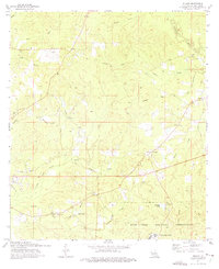
1974 Map of Slagle
USGS Topo · Published 1975About this map
Slagle and the surrounding piney woods of Vernon Parish are defined by the expansive Fort Polk Military Reservation and the industrial remnants of earlier decades. Evidence of former timber and transport activity is clear in the Old Railroad Grade that winds through the terrain, long after the tracks themselves were removed. The map details the transition into military use, specifically at North Fort Polk, where campgrounds and a radio tower stand near the upper reaches of Whisky Chitto Creek. Rural life persists in small clusters of faith and family, marked by the Antioch Ch and its namesake Antioch Cem to the east, and Mt Bethel Ch near the center. The landscape is deeply dissected by a dense network of waterways, including Beason Creek, Castor Creek, and Dry Fork Bayou, which flow through the rolling elevations that characterize this portion of the Louisiana interior.
Find a feature on this map
33 named features on this map. Tap any name to fly to it.
Don’t see what you’re looking for? This feature index may not catch every label — zoom into the map to look around manually.
Map Details
Editions of this 1974 Slagle Map
This is the sole edition of this map. No revisions or reprints were ever made.
Other maps of this area

1941 · Leesville
USGS Topo · 1:62,500

1941 · Slagle
USGS Topo · 1:62,500

1942 · Florien
USGS Topo · 1:62,500

1942 · Kisatchie
USGS Topo · 1:62,500

1943 · Leesville
USGS Topo · 1:62,500

1943 · Kisatchie
USGS Topo · 1:62,500

1944 · Florien
USGS Topo · 1:62,500

1944 · Slagle
USGS Topo · 1:62,500

1946 · Leesville
USGS Topo · 1:62,500

1948 · Leesville
USGS Topo · 1:62,500