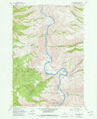
1963 Map of Slate Creek
USGS Topo · Published 1982About this map
The Salmon River carves a dramatic path through the canyon lands of Idaho, serving as the central axis for this 1963 survey. Small settlements and specialized infrastructure, such as the Slate Creek Emergency Airport and the community of White Bird, are established along the river's narrow benches and gravel bars. The mapping reveals a landscape shaped by river navigation and mountain transit, noted by river mile markers and named sandbars like Slicker Bar and Russell Bar.
Find a feature on this map
52 named features on this map. Tap any name to fly to it.
Don’t see what you’re looking for? This feature index may not catch every label — zoom into the map to look around manually.
Map Details
Editions of this 1963 Slate Creek Map
3 editions found
Other maps of this area

1955 · Grangeville
USGS Topo · 1:250,000

1959 · Grangeville
USGS Topo · 1:250,000

1963 · John Day Mtn
USGS Topo · 1:24,000

1963 · Lucile
USGS Topo · 1:24,000

1963 · McKinzie Creek
USGS Topo · 1:24,000

1963 · White Bird Hill
USGS Topo · 1:24,000

1963 · Slate Creek
USGS Topo · 1:24,000

1963 · Kirkwood Creek
USGS Topo · 1:24,000

1963 · Joseph
USGS Topo · 1:24,000

1963 · Grave Point
USGS Topo · 1:24,000