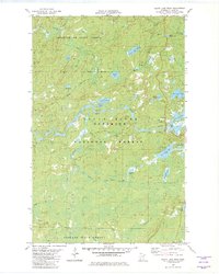
1981 Map of Slate Lake West
USGS Topo · Published 1982About this map
Stony River meanders through a dense lacustrine landscape in this early 1980s survey of Lake County, where three major public forests converge. The map showcases the interface between the Superior National Forest, Bear Island State Forest, and Finland State Forest. A network of winter trails and unimproved roads connects remote water bodies like Denley Lake, Jackpot Lake, and the uniquely named Wampus Lake. While primarily wilderness, the presence of the Happy Wanderer settlement and various Gravel Pit sites indicates the light human footprint of recreation and resource management in this region. The detailed hydrography, including Kelly Creek and Nip Creek, reveals a complex drainage pattern characteristic of the Arrowhead Region’s glaciated terrain before modern development altered these remote northern reaches.
Find a feature on this map
28 named features on this map. Tap any name to fly to it.
Don’t see what you’re looking for? This feature index may not catch every label — zoom into the map to look around manually.
Map Details
Editions of this 1981 Slate Lake West Map
2 editions found
Other maps of this area

1933 · Ely
USGS Topo · 1:62,500

1939 · Ely
USGS Topo · 1:62,500

1952 · Babbitt SE
USGS Topo · 1:24,000

1952 · Babbitt NE
USGS Topo · 1:24,000

1954 · Greenwood Lake
USGS Topo · 1:62,500

1954 · Two Harbors
USGS Topo · 1:250,000

1957 · Two Harbors
USGS Topo · 1:250,000

1957 · Gabbro Lake
USGS Topo · 1:62,500

1958 · Two Harbors
USGS Topo · 1:250,000

1964 · Two Harbors
USGS Topo · 1:250,000