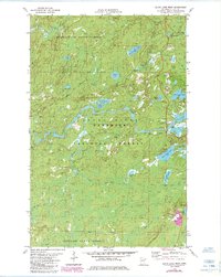
1981 Map of Slate Lake West
USGS Topo · Published 1985About this map
The Stony River winds through the heart of this Northwoods landscape, serving as a central artery between the Bear Island State Forest to the north and the Finland State Forest to the south. This 1980s survey captures a wilderness managed for both conservation and resource extraction, with numerous gravel pits and the prominent Tomahawk Road facilitating movement through the dense timber of the Superior National Forest.
Find a feature on this map
27 named features on this map. Tap any name to fly to it.
Don’t see what you’re looking for? This feature index may not catch every label — zoom into the map to look around manually.
Map Details
Editions of this 1981 Slate Lake West Map
2 editions found
Other maps of this area

1933 · Ely
USGS Topo · 1:62,500

1939 · Ely
USGS Topo · 1:62,500

1952 · Babbitt SE
USGS Topo · 1:24,000

1952 · Babbitt NE
USGS Topo · 1:24,000

1954 · Greenwood Lake
USGS Topo · 1:62,500

1954 · Two Harbors
USGS Topo · 1:250,000

1957 · Two Harbors
USGS Topo · 1:250,000

1957 · Gabbro Lake
USGS Topo · 1:62,500

1958 · Two Harbors
USGS Topo · 1:250,000

1964 · Two Harbors
USGS Topo · 1:250,000