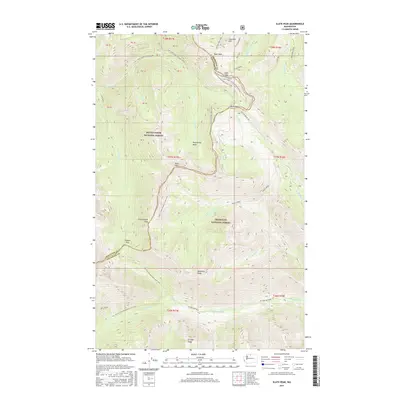
2017 Map of Slate Peak
USGS Topo · Published 2017About this map
Mount Baker National Forest and Okanogan National Forest meet at a high-elevation boundary defined by the crest of the Cascades in this 2017 study. The landscape is dominated by significant peaks including Slate Peak and Haystack Mtn, linked by a network of high-altitude crossings such as Grasshopper Pass, Glacier Pass, and Harts Pass. This area is a critical junction for regional hydrology, where the headwaters of the W Fork Methow and Methow River begin their descent. A long section of the Pacific Crest National Scenic Trail winds through the center of the map, tracing the ridgelines past Tatie Peak and through Ninetynine Basin. The presence of multiple forest development roads, including Natl Forest Develop Road 374 Rd, highlights the managed access to these protected alpine environments at the border of Whatcom and Okanogan counties.
Find a feature on this map
45 named features on this map. Tap any name to fly to it.
Don’t see what you’re looking for? This feature index may not catch every label — zoom into the map to look around manually.
Map Details
Editions of this 2017 Slate Peak Map
This is the sole edition of this map. No revisions or reprints were ever made.
Other maps of this area

1920 · Slate Pass
USGS Topo · 1:125,000

1955 · Concrete
USGS Topo · 1:250,000

1958 · Concrete
USGS Topo · 1:250,000

1962 · Concrete
USGS Topo · 1:250,000

1963 · Washington Pass
USGS Topo · 1:24,000

1963 · Azurite Peak
USGS Topo · 1:24,000

1963 · Slate Peak
USGS Topo · 1:24,000
1963 · Mt. Arriva
USGS Topo · 1:24,000

1963 · Silver Star Mtn.
USGS Topo · 1:24,000
1963 · Robinson Mtn.
USGS Topo · 1:24,000