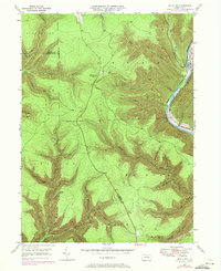
1946 Map of Slate Run
USGS Topo · Published 1972About this map
Pine Creek carves a deep path through the plateau in this 1946 field-checked survey, defining the eastern edge of a landscape shaped by narrow hollows and steep ridges. The settlement of Slate Run serves as the primary hub of activity, situated where the Penn Central railroad tracks follow the river's bend. This transportation corridor was essential for the region's timber and industrial history, connecting the isolated interior of the Pine Creek Gorge to wider markets. High above the valley floor, the Pump Station Fire Tower stands as a sentinel over the vast forests of Brown and McHenry townships. The map documents an intricate network of waterways like Trout Run and Hyner Run, alongside several wells and a small landing strip, illustrating a mid-century balance between wild terrain and resource management at the borders of Lycoming and Clinton counties.
Find a feature on this map
40 named features on this map. Tap any name to fly to it.
Don’t see what you’re looking for? This feature index may not catch every label — zoom into the map to look around manually.
Map Details
Editions of this 1946 Slate Run Map
4 editions found
Other maps of this area

1937 · Waterville
USGS Topo · 1:48,000

1943 · Hyner
USGS Topo · 1:62,500

1943 · Waterville
USGS Topo · 1:62,500

1946 · Young Womans Creek
USGS Topo · 1:24,000

1946 · Antrim
USGS Topo · 1:62,500

1946 · Renovo East
USGS Topo · 1:62,500

1946 · Cedar Run
USGS Topo · 1:24,000

1946 · Slate Run
USGS Topo · 1:24,000

1946 · Renovo East
USGS Topo · 1:24,000

1946 · Glen Union
USGS Topo · 1:24,000
Featured Places
- Brown Township, PA
- McHenry Township, PA
- Slate Run, Brown Township
- Grugan Township, PA
- Stewardson Township, PA