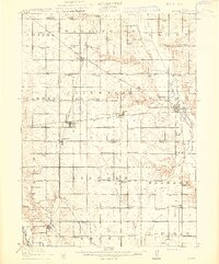
1913 Map of Slater
USGS Topo · Published 1913About this map
Slater and its neighboring agricultural communities are depicted at a peak of rail connectivity during the early twentieth century. This rural landscape across Story and Polk Counties is defined by an intricate network of steel, featuring lines like the Fort Dodge Des Moines and Southern and the Chicago Milwaukee and St Paul. The intersection of these routes fueled the growth of towns such as Huxley, Sheldahl, and Cambridge.
Find a feature on this map
82 named features on this map. Tap any name to fly to it.
Don’t see what you’re looking for? This feature index may not catch every label — zoom into the map to look around manually.
Map Details
Editions of this 1913 Slater Map
2 editions found
Other maps of this area

1905 · Des Moines
USGS Topo · 1:62,500

1907 · Des Moines
USGS Topo · 1:62,500

1908 · Waukee
USGS Topo · 1:62,500

1911 · Madrid
USGS Topo · 1:62,500

1911 · Slater
USGS Topo · 1:62,500

1912 · Ames
USGS Topo · 1:62,500

1913 · Slater
USGS Topo · 1:62,500

1914 · Madrid
USGS Topo · 1:62,500

1914 · Ames
USGS Topo · 1:62,500

1916 · Boone
USGS Topo · 1:62,500