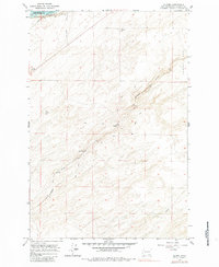
1964 Map of Slater
USGS Topo · Published 1983About this map
Snake River frontage and the expansive high ground of Eureka Flat define this mid-century portrait of Walla Walla County. The landscape is shaped by the presence of Lake Sacajawea, with its normal pool elevation of 440 feet maintained by federal water projects. The local economy and infrastructure are clearly rooted in transportation and agriculture, evidenced by the dual presence of the Union Pacific and Northern Pacific railroads crossing the terrain.
Find a feature on this map
16 named features on this map. Tap any name to fly to it.
Don’t see what you’re looking for? This feature index may not catch every label — zoom into the map to look around manually.
Map Details
Editions of this 1964 Slater Map
2 editions found
Other maps of this area

1915 · Wallulah
USGS Topo · 1:96,000

1918 · Wallula
USGS Topo · 1:125,000

1953 · Walla Walla
USGS Topo · 1:250,000

1958 · Walla Walla
USGS Topo · 1:250,000

1964 · Wallula
USGS Topo · 1:24,000

1964 · Zangar Junction
USGS Topo · 1:24,000

1964 · Levey SW
USGS Topo · 1:24,000

1964 · Levey SE
USGS Topo · 1:24,000

1964 · Slater
USGS Topo · 1:24,000

1964 · Humorist
USGS Topo · 1:24,000