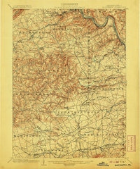
1902 Map of Slatington
USGS Topo · Published 1907About this map
Slatington and the surrounding slate-producing region of Lehigh County are captured here at the turn of the century, a period of intensive industrial growth. The landscape is defined by the Consolidated Quarries near Slatedale and the intricate network of competing rail lines like the Central Railroad of New Jersey and the Lehigh Valley Railroad that follow the winding course of the Lehigh River. From the heights of Bake Oven Knob on Blue Mountain down to the fertile valleys of Upper Macungie, the map reveals a dense settlement pattern of small villages and industrial sites. Local landmarks such as Lehigh Furnace and Jordan Church serve as anchors for genealogical research, while the presence of the Catasauqua and Fogelsville Railroad illustrates the vital transport corridors moving minerals and goods toward Allentown and beyond.
Find a feature on this map
158 named features on this map. Tap any name to fly to it.
Don’t see what you’re looking for? This feature index may not catch every label — zoom into the map to look around manually.
Map Details
Editions of this 1902 Slatington Map
5 editions found
Other maps of this area

1888 · Quakertown
USGS Topo · 1:62,500

1889 · Hazleton
USGS Topo · 1:62,500

1890 · Quakertown
USGS Topo · 1:62,500

1891 · Hazleton
USGS Topo · 1:62,500

1893 · Hazleton
USGS Topo · 1:62,500

1894 · Reading
USGS Topo · 1:62,500

1894 · Allentown
USGS Topo · 1:62,500

1894 · Quakertown
USGS Topo · 1:62,500

1902 · Boyertown
USGS Topo · 1:62,500

1902 · Slatington
USGS Topo · 1:62,500